IMAGES TAKEN NEAR TO
Linden Drive, SHEERNESS, ME12 1LG
Introduction
This page details the photographs taken nearby to Linden Drive, ME12 1LG by members of the Geograph project.
The Geograph project started in 2005 with the aim of publishing, organising and preserving representative images for every square kilometre of Great Britain, Ireland and the Isle of Man.

There are currently over 7.5m images from over14,400 individuals and you can help contribute to the project by visiting https://www.geograph.org.uk
Image Map
Images are licensed for reuse under creativecommons.org/licenses/by-sa/2.0
Notes
- Clicking on the map will re-center to the selected point.
- The higher the marker number, the further away the image location is from the centre of the postcode.
Image Listing (21 Images Found)
Images are licensed for reuse under creativecommons.org/licenses/by-sa/2.0
Image
Details
Distance
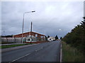
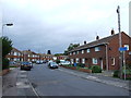
2
Cromwell Road, West Minster
This road used to be lined with houses before West Minster was demolished to make way for a new road in the 1970s.
Image: © Chris Whippet
Taken: 26 Oct 2013
0.06 miles
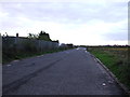
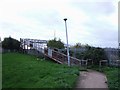
3

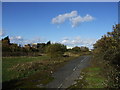
Footbridge over Sheerness Railway
Looking towards Sheerness.
Unused footbridge from housing estate, to waste ground used by lorries for overnight parking.
Image: © David Anstiss
Taken: 22 Oct 2008
0.06 miles
6
Footbridge over the Railway, West Minster
Image: © Chris Whippet
Taken: 26 Oct 2013
0.07 miles
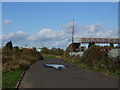
7
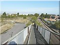
Footbridge over the railway line to Sheerness
The bridge carries a footpath between Linden Drive (where there is a fingerpost) and Brielle Way. It is equipped with a trough to make it easier for cyclists to ascend and descend the stepped-ramps (although they are advised to dismount). Cromwell Road to the left of the bridge is blocked by a grassy barrier and beyond that, just peters out. I wonder if it was the former alignment of Brielle Way.
Image: © John Baker
Taken: 7 Oct 2012
0.09 miles
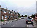
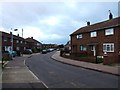
9
Cromwell Road, West Minster
This road used to be lined with houses before West Minster was demolished to make way for a new road in the 1970s.
Image: © Chris Whippet
Taken: 3 Nov 2013
0.10 miles