IMAGES TAKEN NEAR TO
Anchor Lane, Sheerness Docks, SHEERNESS, ME12 1HX
Introduction
This page details the photographs taken nearby to Anchor Lane, Sheerness Docks, ME12 1HX by members of the Geograph project.
The Geograph project started in 2005 with the aim of publishing, organising and preserving representative images for every square kilometre of Great Britain, Ireland and the Isle of Man.

There are currently over 7.5m images from over14,400 individuals and you can help contribute to the project by visiting https://www.geograph.org.uk
Image Map
Images are licensed for reuse under creativecommons.org/licenses/by-sa/2.0
Notes
- Clicking on the map will re-center to the selected point.
- The higher the marker number, the further away the image location is from the centre of the postcode.
Image Listing (134 Images Found)
Images are licensed for reuse under creativecommons.org/licenses/by-sa/2.0
Image
Details
Distance
1
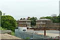
North and South Gatehouses, Sheerness Dockyard
Built 1820 for the naval dockyard here. Grade II listed buildings. Now offices.
Image: © Robin Webster
Taken: 16 May 2018
0.07 miles
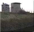
2
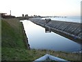
Moat at Sheerness Dockyard
Between the sea wall and the eastern end of the dockyard. Part of the sea and naval defences, the housing half way along the sea wall is a pump. For details of the buildings left of centre in the picture, see Image
Image: © Penny Mayes
Taken: 21 Jan 2006
0.07 miles
4

King William Lion Monument, Sheerness Dockyard
The rampant lion dates from the 17th century and was removed from the main gate of the 1st Garrison Fort. It is Grade II listed. In the background is the former Captain Superintendent's House.
Image: © pam fray
Taken: 14 Oct 2017
0.07 miles
7
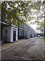
Dockyard Terrace, Sheerness
A row of Georgian properties, some still undergoing restoration, to the south of Church Road and west of the former Royal Dockyard Church.
Image: © pam fray
Taken: 14 Oct 2017
0.11 miles
8
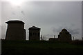
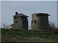
Centre Bastion, Sheerness dockyard
This http://ads.ahds.ac.uk/catalogue/search/fr.cfm?rcn=NMR_NATINV-924089 says of these buildings "The most prominent features, two circular concrete towers and an elevated fire control building were possibly constructed c1913. Each of the towers had a gun emplacement, one also has a Second World War observation post." The second circular concrete tower is just visible on the right.
Image: © Penny Mayes
Taken: 21 Jan 2006
0.11 miles
9

Sign on Wall near Anchor Monument
Gives history about Bluetown, Sheerness.
On Sheerness Dock Wall on High Street.
Image: © David Anstiss
Taken: 22 Oct 2008
0.11 miles
10

Anchor Monument on High Street, Bluetown, Sheerness
Sign seen behind Anchor on photo Image giving history of Bluetown.
One Way sign points to West Street and A249, exit out of Bluetown.
Image: © David Anstiss
Taken: 22 Oct 2008
0.11 miles