IMAGES TAKEN NEAR TO
Corys Road, ROCHESTER, ME1 1GT
Introduction
This page details the photographs taken nearby to Corys Road, ME1 1GT by members of the Geograph project.
The Geograph project started in 2005 with the aim of publishing, organising and preserving representative images for every square kilometre of Great Britain, Ireland and the Isle of Man.

There are currently over 7.5m images from over14,400 individuals and you can help contribute to the project by visiting https://www.geograph.org.uk
Image Map
Images are licensed for reuse under creativecommons.org/licenses/by-sa/2.0
Notes
- Clicking on the map will re-center to the selected point.
- The higher the marker number, the further away the image location is from the centre of the postcode.
Image Listing (947 Images Found)
Images are licensed for reuse under creativecommons.org/licenses/by-sa/2.0
Image
Details
Distance
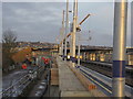
1
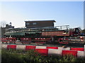
Parts of the new Rochester railway station
As seen from Rochester Riverside, looking across the railway storage compound.
Unsure what the part is ? Bridge or something else.
In the background is a signal box.
Image: © David Anstiss
Taken: 6 Dec 2014
0.01 miles
2
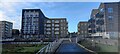
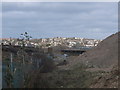
Housing on Cory's Road
As seen from the riverside path beside Common Creek Wharf.
These buildings have been built on a former Industrial wharf area, which is being converted into housing blocks.
A wharf (on the River Medway) is on the left, but at low tide is full of seaweed.
Image: © David Anstiss
Taken: 20 Dec 2022
0.01 miles
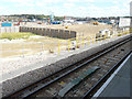
4
Railway embankment, Rochester
The railway embankment on the left has been cleared of trees and shrubs.
On the right is a large spoil heap made from the digging of the new foundations (in the background) for the 'new' Rochester Railway Station.
In the far background is the suburbs of Strood.
Image: © David Anstiss
Taken: 9 Feb 2014
0.02 miles
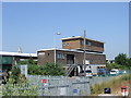
5
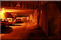
Railway bridge over Blue Boar Lane, Rochester
Another access point to Medway Council's new Rochester Riverside Walk.
New development area north-east of railway.
Rochester Cathedral in background.
Railway comes from London/Strood on right, heading towards Rochester/Chatham on left.
Image: © David Anstiss
Taken: 11 Nov 2008
0.03 miles
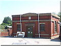
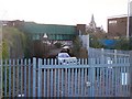
7
Station signal box on Blue Boar Lane, beside Rochester Railway Station Platforms
This station signal box was previous further up the line from the old station. Now incorporated within the new re-located railway station.
Image: © David Anstiss
Taken: 16 Dec 2015
0.04 miles
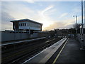
8
Finishing landscaping to the re-located Railway Station
The new Station opened on the 13 December 2015, but work was still carrying on around the platforms for the next few weeks.
As seen from platform 1 (for trains heading towards London).
Image: © David Anstiss
Taken: 16 Dec 2015
0.04 miles
9
Looking ESE towards a building site
Planning permission has been approved, with conditions, by Medway Council under application number MC/15/0977 for a “hybrid planning application seeking outline permission for the erection of up to 1,400 dwellings including a primary school and nursery (D1 use), up to 1,200sqm of commercial floorspace (A1/A2/A3/A4/B1/D1 and D2 uses) together with a pedestrian footbridge, parking, open space and landscaping. Full permission for phase 1, 2 and 3 of the development consisting of the erection of 489 dwellings (of the 1,400 total), the provision of a hotel (use Class C1), 885sqm of commercial floorspace (A1/A2/A3/A4/B1/D1 and D2 uses) along with site access/spine road, parking, open space and landscaping”. The development has been named Rochester Riverside. This is a grandstand view from platform 3 of Rochester railway station.
This is a similar image when Image, taken seventeen months ago.
Image: © John Baker
Taken: 31 Jul 2018
0.04 miles