IMAGES TAKEN NEAR TO
Limehouse Wharf, ROCHESTER, ME1 1GQ
Introduction
This page details the photographs taken nearby to Limehouse Wharf, ME1 1GQ by members of the Geograph project.
The Geograph project started in 2005 with the aim of publishing, organising and preserving representative images for every square kilometre of Great Britain, Ireland and the Isle of Man.

There are currently over 7.5m images from over14,400 individuals and you can help contribute to the project by visiting https://www.geograph.org.uk
Image Map
Images are licensed for reuse under creativecommons.org/licenses/by-sa/2.0
Notes
- Clicking on the map will re-center to the selected point.
- The higher the marker number, the further away the image location is from the centre of the postcode.
Image Listing (1050 Images Found)
Images are licensed for reuse under creativecommons.org/licenses/by-sa/2.0
Image
Details
Distance
1
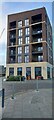
Rochester Riverside Co-Op
On Cory's Road.
Image: © David Anstiss
Taken: 20 Dec 2022
0.01 miles
2

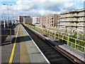
Buildings on Cory's Road
Looking from Common Creek Wharf.
Tallest building is the Co-Op store with flats above and beside it a Costa coffee shop with more flats above it. Rochester Cathedral tower can be seen in the background. With the light coloured Rochester Railway station multi-story carpark on the righthand side. The crane on the left, shows that more construction work is taking place on the former industrial wharf area.
Image: © David Anstiss
Taken: 20 Dec 2022
0.01 miles
3
Looking NNW towards a building site
Planning permission has been approved, with conditions, by Medway Council under application number MC/15/0977 for a “hybrid planning application seeking outline permission for the erection of up to 1,400 dwellings including a primary school and nursery (D1 use), up to 1,200sqm of commercial floorspace (A1/A2/A3/A4/B1/D1 and D2 uses) together with a pedestrian footbridge, parking, open space and landscaping. Full permission for phase 1, 2 and 3 of the development consisting of the erection of 489 dwellings (of the 1,400 total), the provision of a hotel (use Class C1), 885sqm of commercial floorspace (A1/A2/A3/A4/B1/D1 and D2 uses) along with site access/spine road, parking, open space and landscaping”. The development has been named Rochester Riverside. This is a grandstand view from platform 3 Image
Image: © John Baker
Taken: 14 Feb 2017
0.01 miles
4
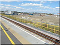
Looking north towards a building site
Planning permission has been approved, with conditions, by Medway Council under application number MC/15/0977 for a “hybrid planning application seeking outline permission for the erection of up to 1,400 dwellings including a primary school and nursery (D1 use), up to 1,200sqm of commercial floorspace (A1/A2/A3/A4/B1/D1 and D2 uses) together with a pedestrian footbridge, parking, open space and landscaping. Full permission for phase 1, 2 and 3 of the development consisting of the erection of 489 dwellings (of the 1,400 total), the provision of a hotel (use Class C1), 885sqm of commercial floorspace (A1/A2/A3/A4/B1/D1 and D2 uses) along with site access/spine road, parking, open space and landscaping”. The development has been named Rochester Riverside. This is a grandstand view from platform 3 of Rochester railway station.
This is a similar image when Image taken seventeen months ago.
Image: © John Baker
Taken: 31 Jul 2018
0.02 miles
5
Looking ENE towards a building site
Planning permission has been approved, with conditions, by Medway Council under application number MC/15/0977 for a “hybrid planning application seeking outline permission for the erection of up to 1,400 dwellings including a primary school and nursery (D1 use), up to 1,200sqm of commercial floorspace (A1/A2/A3/A4/B1/D1 and D2 uses) together with a pedestrian footbridge, parking, open space and landscaping. Full permission for phase 1, 2 and 3 of the development consisting of the erection of 489 dwellings (of the 1,400 total), the provision of a hotel (use Class C1), 885sqm of commercial floorspace (A1/A2/A3/A4/B1/D1 and D2 uses) along with site access/spine road, parking, open space and landscaping”. The development has been named Rochester Riverside. This is a grandstand view from platform 3 of Rochester railway station.
Image: © John Baker
Taken: 24 Mar 2019
0.02 miles
6
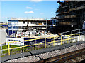
Looking north towards a building site
Planning permission has been approved, with conditions, by Medway Council under application number MC/15/0977 for a “hybrid planning application seeking outline permission for the erection of up to 1,400 dwellings including a primary school and nursery (D1 use), up to 1,200sqm of commercial floorspace (A1/A2/A3/A4/B1/D1 and D2 uses) together with a pedestrian footbridge, parking, open space and landscaping. Full permission for phase 1, 2 and 3 of the development consisting of the erection of 489 dwellings (of the 1,400 total), the provision of a hotel (use Class C1), 885sqm of commercial floorspace (A1/A2/A3/A4/B1/D1 and D2 uses) along with site access/spine road, parking, open space and landscaping”. The development has been named Rochester Riverside. This is a grandstand view from platform 3 of Rochester railway station.
This view Image was taken in March 2019.
Image: © John Baker
Taken: 26 Feb 2020
0.02 miles
7
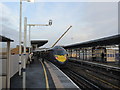
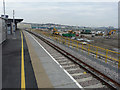
Platform 1 at Rochester Railway Station
With a high speed train about to head to St Pancras International.
Image: © David Anstiss
Taken: 16 Dec 2015
0.03 miles
8
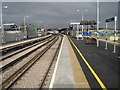
Rochester railway station, Kent
Opened in 2015 by Network Rail on the line from London Victoria to Faversham, this station replaced an earlier station some 500m behind the camera position.
View north west towards Strood and London. At one time, Strood and Rochester had five stations between them on two competing tracks. This station is adjacent to the site of the one called Rochester Common (1891-1911), which is now covered by a multi-storey car park just beyond the platform buildings in the distance.
Image: © Nigel Thompson
Taken: 3 Feb 2016
0.03 miles
9
Future Rochester railway station position?
Medway Council has approved Network Rail plans for a new £26 million re-located railway station in Rochester.
The new station has been designed to be able to accommodate longer trains than the current station, helping boost capacity and providing more seats for passengers. An integrated transport hub will provide better links to other types of public transport. Several spaces of Corporation Road car-park will be lost, but a new subway will lead under the railway to Rochester Riverside (a huge housing and development site beside the River Medway). Which also includes a new station car park.
The new station is due to be completed in winter 2015
The old station is (Image), is about 600 yards right of here.
Image: © David Anstiss
Taken: 12 Jul 2013
0.03 miles
10
Subway to Rochester Riverside
This new subway is part of the new re-located Rochester Railway Station construction works.
Image: © David Anstiss
Taken: 6 Dec 2014
0.03 miles