IMAGES TAKEN NEAR TO
North Road, QUEENBOROUGH, ME11 5EL
Introduction
This page details the photographs taken nearby to North Road, ME11 5EL by members of the Geograph project.
The Geograph project started in 2005 with the aim of publishing, organising and preserving representative images for every square kilometre of Great Britain, Ireland and the Isle of Man.

There are currently over 7.5m images from over14,400 individuals and you can help contribute to the project by visiting https://www.geograph.org.uk
Image Map
Images are licensed for reuse under creativecommons.org/licenses/by-sa/2.0
Notes
- Clicking on the map will re-center to the selected point.
- The higher the marker number, the further away the image location is from the centre of the postcode.
Image Listing (130 Images Found)
Images are licensed for reuse under creativecommons.org/licenses/by-sa/2.0
Image
Details
Distance
1
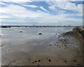
The West Swale at Queenborough
King Edward III had the town renamed after his Queen, Philippa of Hainault, and conferred upon it the rights of a free borough, with a governing body of a mayor and two bailiffs. He granted Queenborough a charter in 1366 and two years later bestowed the duties of a royal borough upon it. A full history of this interesting place can be seen at https://en.wikipedia.org/wiki/Queenborough
This view is from the seafront. The cranes in the centre are on the Isle of Grain.
Image: © Marathon
Taken: 4 Aug 2020
0.04 miles
3
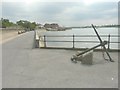
Looking southeast along the waterfront
Penny Mayes’ Image has all the information about the plaque that the anchor is resting on.
Image: © John Baker
Taken: 27 Jul 2014
0.06 miles
5
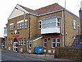
Queenborough Social Club
Built 1928, the club stands in North Road.
Image: © Richard Dorrell
Taken: 9 Mar 2008
0.06 miles
6
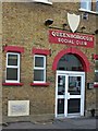
Entrance to Queenborough Social Club
The building of the club must have been an important local event, as stones were laid along the front by councillors. The one next to the front door reads "This stone was laid by C.R. Stevens Mayor of Queenborough, Feb 4th 1928".
Image: © Richard Dorrell
Taken: 9 Mar 2008
0.07 miles
8
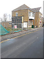
Building site, North Road
Planning permission has been granted by Swale Borough Council under application number 15/508928/FULL for the “demolition of existing building. Erection of 2 two bedroom and 2 three bedroom terraced dwellings with associated car parking to rear”.
The site is on land adjacent to Image; part of the building, which has been demolished, can be seen to the left of the social club.
Image: © John Baker
Taken: 2 Dec 2018
0.08 miles
10
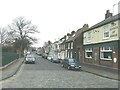
High Street, Queenborough
As seen from its junctions with Park Street (to the left) and West Street (to the right).
Image: © John Baker
Taken: 8 Jan 2012
0.08 miles