IMAGES TAKEN NEAR TO
First Avenue, QUEENBOROUGH, ME11 5DU
Introduction
This page details the photographs taken nearby to First Avenue, ME11 5DU by members of the Geograph project.
The Geograph project started in 2005 with the aim of publishing, organising and preserving representative images for every square kilometre of Great Britain, Ireland and the Isle of Man.

There are currently over 7.5m images from over14,400 individuals and you can help contribute to the project by visiting https://www.geograph.org.uk
Image Map
Images are licensed for reuse under creativecommons.org/licenses/by-sa/2.0
Notes
- Clicking on the map will re-center to the selected point.
- The higher the marker number, the further away the image location is from the centre of the postcode.
Image Listing (65 Images Found)
Images are licensed for reuse under creativecommons.org/licenses/by-sa/2.0
Image
Details
Distance
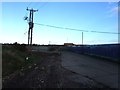
1
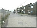
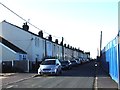
First Avenue, Rushenden
As seen from the junction with Well Road. Most of the buildings along this road were encased in scaffolding to enable cavity wall installation.
Image: © John Baker
Taken: 8 Jan 2012
0.02 miles
6
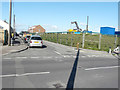
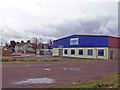
Construction site, Rushenden Road
The Image has been removed and this image shows some of the equipment in use for the redevelopment of the site, which is to be known as Nelson Vue.
Planning permission was granted by Swale Borough Council under application number 16/507298/FULL for “phase 1 of the redevelopment of land off Rushenden Road, comprising 101 dwellings and associated access, parking and landscaping”.
Image: © John Baker
Taken: 3 Oct 2017
0.08 miles
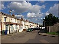
7
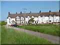
Terrace at Rushenden
This terrace dates from just before the First World War, judging by the date on the end house. This is at the western end of Rushenden and The Swale is just behind. Rushenden is a rather strange place, separated from Queenborough by industry and quite isolated.
Image: © Marathon
Taken: 28 May 2016
0.08 miles
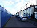
8
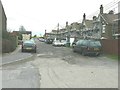
Well Road, Rushenden
As seen from its junction with First Avenue. The backs of the houses are those in Alsager Avenue. The scaffolding may have been erected to enable cavity wall insulation as this was being installed in most of the houses in First Avenue.
Image: © John Baker
Taken: 8 Jan 2012
0.08 miles
10
Site of Community project
The sign on the front of this disused building says "Site acquired for the Queenborough and Rushenden Community". There is no indication as to what will actually be provided here.
Image: © Richard Dorrell
Taken: 9 Mar 2008
0.09 miles