IMAGES TAKEN NEAR TO
South Street, QUEENBOROUGH, ME11 5AF
Introduction
This page details the photographs taken nearby to South Street, ME11 5AF by members of the Geograph project.
The Geograph project started in 2005 with the aim of publishing, organising and preserving representative images for every square kilometre of Great Britain, Ireland and the Isle of Man.

There are currently over 7.5m images from over14,400 individuals and you can help contribute to the project by visiting https://www.geograph.org.uk
Image Map
Images are licensed for reuse under creativecommons.org/licenses/by-sa/2.0
Notes
- Clicking on the map will re-center to the selected point.
- The higher the marker number, the further away the image location is from the centre of the postcode.
Image Listing (155 Images Found)
Images are licensed for reuse under creativecommons.org/licenses/by-sa/2.0
Image
Details
Distance
4
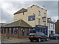
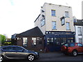
The Flying Dutchman public house
Located in the High Street. The white house next door is dated 1856.
Image: © Richard Dorrell
Taken: 9 Mar 2008
0.02 miles
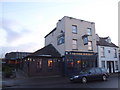
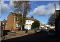
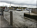
6
Boatyard view, South Street Queenborough
Image: © David Martin
Taken: 21 Jul 2021
0.03 miles
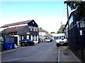
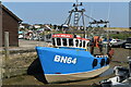
7
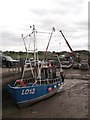
Fishing Boat, Queenborough
Beside Queenborough Harbour at low-tide.
At low-tide the creek is not navigable.
Image: © David Anstiss
Taken: 9 Jun 2012
0.03 miles
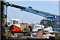
8
Fishing boat "Ruth Imelda" at Queenborough Quay
Image: © David Martin
Taken: 21 Jul 2021
0.03 miles
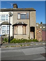
9
Looking SSE across The Creek
To buildings on the other side, some of which are in a very bad state of repair.
Image: © John Baker
Taken: 9 Oct 2016
0.03 miles