IMAGES TAKEN NEAR TO
Bristol Close, SITTINGBOURNE, ME10 5BG
Introduction
This page details the photographs taken nearby to Bristol Close, ME10 5BG by members of the Geograph project.
The Geograph project started in 2005 with the aim of publishing, organising and preserving representative images for every square kilometre of Great Britain, Ireland and the Isle of Man.

There are currently over 7.5m images from over14,400 individuals and you can help contribute to the project by visiting https://www.geograph.org.uk
Image Map
Images are licensed for reuse under creativecommons.org/licenses/by-sa/2.0
Notes
- Clicking on the map will re-center to the selected point.
- The higher the marker number, the further away the image location is from the centre of the postcode.
Image Listing (12 Images Found)
Images are licensed for reuse under creativecommons.org/licenses/by-sa/2.0
Image
Details
Distance
1
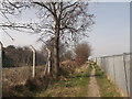
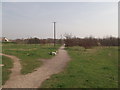
Footpath to Bobbing
This path leads from the B2006 (in Milton Regis) through a community woodland, and then alongside the Sittingbourne to London railway line (on the left).
Image: © David Anstiss
Taken: 22 Mar 2012
0.01 miles
2
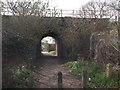
Subway / tunnel to Woolett Road, Sittingbourne
This path leads from a footpath, (within a community woodland) heading from the B2006 to Bobbing.
It passes under the main Sittingbourne to London railway.
Image: © David Anstiss
Taken: 22 Mar 2012
0.02 miles
3
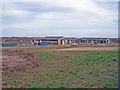
New office accommodation, Sittingbourne
Nearly ready for occupation, these are the first new office buildings on this site.
Image: © Richard Dorrell
Taken: 3 Feb 2008
0.09 miles
4
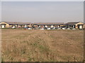
New offices on Velum Drive, Milton Regis
As seen from the footpath to Bobbing.
These offices are the 1st part of a new development area, along the B2006 (which heads to the A249 dual carriageway from Sittingbourne).
Eventually all the parcels of land will be bought and developed on.
Image: © David Anstiss
Taken: 22 Mar 2012
0.10 miles
5
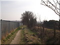
Paths in Milton Regis Community Woodland
This woodland is between the B2006 and the junction of 2 railway lines (the Sheerness spur-line and the main London line).
It serves the nearby new housing estate in Milton Regis.
A public footpath leads through the woodland to Bobbing.
Image: © David Anstiss
Taken: 22 Mar 2012
0.16 miles
6
Footpath to Milton Regis
This path leads from Sheppey Way, Bobbing, alongside the London to
Sittingbourne railway line (on the right), then through a community woodland, before reaching the B2006 (in Milton Regis).
Image: © David Anstiss
Taken: 22 Mar 2012
0.18 miles
7
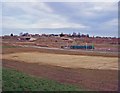
Office development site, near Sittingbourne
Once this development site has been filled in, there will be no open space between Bobbing and Sittingbourne.
Image: © Richard Dorrell
Taken: 3 Feb 2008
0.18 miles
8
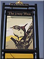
The Jenny Wren Pub Sign, Milton Regis
Sign for the Image
Image: © David Anstiss
Taken: 22 Mar 2012
0.19 miles
9
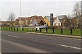
The Jenny Wren public house, Sittingbourne
Image: © Mark Anderson
Taken: 3 Jan 2019
0.19 miles
10
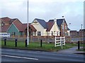
The Jenny Wren, Sittingbourne
On Quartz Way in Milton Regis. This new pub has been built in a new large housing estate on the west of Sittingbourne. Seen from the B2006 Staplehurst Road. It is currently recruiting staff for its opening in February 2010.
Image: © David Anstiss
Taken: 25 Dec 2009
0.20 miles