IMAGES TAKEN NEAR TO
Highsted Road, SITTINGBOURNE, ME10 4PS
Introduction
This page details the photographs taken nearby to Highsted Road, ME10 4PS by members of the Geograph project.
The Geograph project started in 2005 with the aim of publishing, organising and preserving representative images for every square kilometre of Great Britain, Ireland and the Isle of Man.

There are currently over 7.5m images from over14,400 individuals and you can help contribute to the project by visiting https://www.geograph.org.uk
Image Map
Images are licensed for reuse under creativecommons.org/licenses/by-sa/2.0
Notes
- Clicking on the map will re-center to the selected point.
- The higher the marker number, the further away the image location is from the centre of the postcode.
Image Listing (9 Images Found)
Images are licensed for reuse under creativecommons.org/licenses/by-sa/2.0
Image
Details
Distance
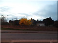
4
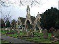
Chapel of Rest, Sittingbourne Cemetery
Image: © Chris Whippet
Taken: 13 Jan 2015
0.20 miles
5
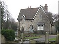
Cemetery Lodge, Sittingbourne
Grade II Listed Lodge of Sittingbourne Cemetery on Bell Road.
Also Known as 46, Bell Road.
See http://www.britishlistedbuildings.co.uk/en-175710-46-sittingbourne for more details about the building.
Image: © David Anstiss
Taken: 26 Jan 2011
0.20 miles
7

Chapel of Rest in Sittingbourne Cemetery
Close to Bell Road.
Image: © David Anstiss
Taken: 26 Jan 2011
0.21 miles
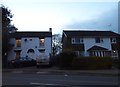
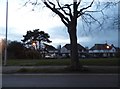
8
Bungalow on Bell Street, Sittingbourne
Image: © David Howard
Taken: 19 Mar 2017
0.22 miles
9
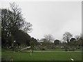
Sittingbourne Cemetery
This large cemetery is beside Bell Road. Also accessed via Avenue of Remembrance and the recreation ground beside Albany Road.
Image: © David Anstiss
Taken: 26 Jan 2011
0.23 miles