IMAGES TAKEN NEAR TO
Fairview Road, SITTINGBOURNE, ME10 4FF
Introduction
This page details the photographs taken nearby to Fairview Road, ME10 4FF by members of the Geograph project.
The Geograph project started in 2005 with the aim of publishing, organising and preserving representative images for every square kilometre of Great Britain, Ireland and the Isle of Man.

There are currently over 7.5m images from over14,400 individuals and you can help contribute to the project by visiting https://www.geograph.org.uk
Image Map
Images are licensed for reuse under creativecommons.org/licenses/by-sa/2.0
Notes
- Clicking on the map will re-center to the selected point.
- The higher the marker number, the further away the image location is from the centre of the postcode.
Image Listing (75 Images Found)
Images are licensed for reuse under creativecommons.org/licenses/by-sa/2.0
Image
Details
Distance
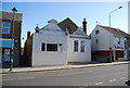
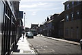
3
East Street, Sittingbourne
This is pretty much the town centre
Image: © David Howard
Taken: 19 Jun 2016
0.01 miles
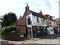
8
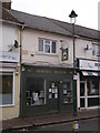
Sittingbourne Heritage Museum
On East Street.
Opening hours: 10am-4pm on Saturdays from Easter to October.
See http://www.sittingbourne-museum.co.uk/ for more details.
Image: © David Anstiss
Taken: 11 Mar 2014
0.04 miles
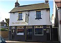
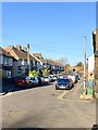
9
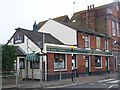
The Wheatsheaf Public House, Sittingbourne
On junction of East Street and South Avenue.
Image: © David Anstiss
Taken: 5 Nov 2008
0.05 miles
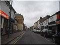
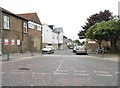
10
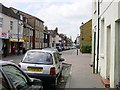
East Street looking West
Once part of the main A2 Watling Street this part of the town has been badly served by the town planners and has lost most of its passing trade since it became a one way street. The church visible in the distance is the United Reformed Church on the High Street.
Image: © Penny Mayes
Taken: 12 May 2005
0.06 miles