IMAGES TAKEN NEAR TO
Symmonds Drive, Eurolink Business Park, SITTINGBOURNE, ME10 3SY
Introduction
This page details the photographs taken nearby to Symmonds Drive, Eurolink Business Park, ME10 3SY by members of the Geograph project.
The Geograph project started in 2005 with the aim of publishing, organising and preserving representative images for every square kilometre of Great Britain, Ireland and the Isle of Man.

There are currently over 7.5m images from over14,400 individuals and you can help contribute to the project by visiting https://www.geograph.org.uk
Image Map
Images are licensed for reuse under creativecommons.org/licenses/by-sa/2.0
Notes
- Clicking on the map will re-center to the selected point.
- The higher the marker number, the further away the image location is from the centre of the postcode.
Image Listing (33 Images Found)
Images are licensed for reuse under creativecommons.org/licenses/by-sa/2.0
Image
Details
Distance
1
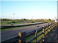
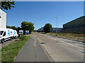
Bayford Meadows Karting Circuit
On Symonds Drive in Eurolink Commercial Park.
Image: © David Anstiss
Taken: 4 Dec 2008
0.11 miles
4
Abandoned boat, Milton Creek, Sittingbourne
Image: © Chris Whippet
Taken: 15 Aug 2013
0.18 miles
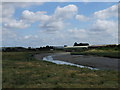
5
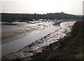
The Milton Creek heading to Sittingbourne
As seen from the Saxon Shore Way (long distance path) within Milton Creek Country Park.
The creek (seen at low tide) heads from Kemsley towards the town.
In the background are warehouses in Crown Quay industrial estate.
Image: © David Anstiss
Taken: 22 Mar 2012
0.19 miles
6
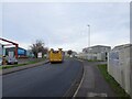
Fire Engine on Castle Road
Speeding truck with sirens and lights flashing heads up the B2005 through the Eurolink Industrial Park.
Image: © David Anstiss
Taken: 28 Jan 2022
0.20 miles
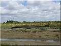
9
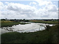
Barge Wreck, Milton Creek
This ruins of a barge is in the mudflats of the Milton Creek near Sittingbourne.
Seen from the Saxon Shore Way (long distance path) within Milton Creek Country Park.
Image: © David Anstiss
Taken: 22 Mar 2012
0.21 miles
10
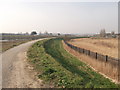
Saxon Shore Way to Sittingbourne
The long distance path leads from Church Marshes along the Milton Creek towards the town.
The reeds on the right are around a sewage works.
Image: © David Anstiss
Taken: 22 Mar 2012
0.21 miles