IMAGES TAKEN NEAR TO
Crown Quay Lane, SITTINGBOURNE, ME10 3SL
Introduction
This page details the photographs taken nearby to Crown Quay Lane, ME10 3SL by members of the Geograph project.
The Geograph project started in 2005 with the aim of publishing, organising and preserving representative images for every square kilometre of Great Britain, Ireland and the Isle of Man.

There are currently over 7.5m images from over14,400 individuals and you can help contribute to the project by visiting https://www.geograph.org.uk
Image Map
Images are licensed for reuse under creativecommons.org/licenses/by-sa/2.0
Notes
- Clicking on the map will re-center to the selected point.
- The higher the marker number, the further away the image location is from the centre of the postcode.
Image Listing (48 Images Found)
Images are licensed for reuse under creativecommons.org/licenses/by-sa/2.0
Image
Details
Distance
1
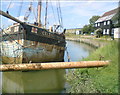
Dolphin Yard Sailing Barge Museum, Sittingbourne
The site includes the original sail loft and forge which have been converted to a museum devoted to the history of the Thames Sailing Barge and the associated industries of brick and cement making which once sustained the local fleet of barges.
Image: © Penny Mayes
Taken: 31 May 2004
0.05 miles
2
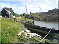
The Celtic at the Barge Museum
The Celtic was once a thriving Barge sailing in and out of the Thames Gateway and was built in 1905. It is now under restoration from an enthusiast.
Image: © Joe White
Taken: 16 Jun 2008
0.05 miles
3
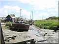
Dolphin Sailing Barge Museum
Looking across Milton Creek, the timbers in the foreground allow a barge to rest above the water at low tide to facilitate maintenance work. The museum is to move to a new home in the near future.
Image: © Penny Mayes
Taken: 31 May 2004
0.08 miles
4
Dolphin Yard Sailing Barge Museum
This is the old forge for the barge repair works. It is situated on a tidal inlet from the East banks of Milton Creek.
Image: © Joe White
Taken: 16 Jun 2008
0.08 miles
5
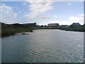
Boat reclaimed by nature, Milton Creek, Sittingbourne
Image: © Chris Whippet
Taken: 15 Aug 2013
0.12 miles
6

TS Wyvern, Sittingbourne
This group of buildings, known as Training Ship Wyvern, is used by the Sea Cadet Sittingbourne Sea Cadet Corps, who have various vessels on the Milton Creek. The wooden building was opened in October 1976 by Sir Roger Moate, MP for Faversham.
Image: © David Anstiss
Taken: 16 Feb 2013
0.12 miles
7
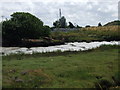
High Tide on Milton Creek
Just to the East of the inlet to the Barge Museum and looking in the background is the much disputed Crown Quay.
Image: © Joe White
Taken: 16 Jun 2008
0.12 miles
8
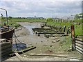
Barge Wreck, Milton Creek
This ruins of a barge is in the mudflats of the Milton Creek near Sittingbourne.
Seen from the Saxon Shore Way (long distance path) within Milton Creek Country Park.
Image: © David Anstiss
Taken: 22 Mar 2012
0.13 miles
9
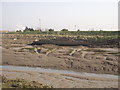
Looking north along Crown Quay Lane
Just beyond the entrance to Odds Timber, notices have been attached to the hoarding which read “Bellway land acquired”.
Image: © John Baker
Taken: 17 Jan 2017
0.14 miles
10
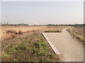
Saxon Shore Way in Milton Creek Country Park
The long distance path, leads beside Milton Creek (on the right) via a path around a reed filled marsh land. The path heads towards a large open section of the park and Kemsley.
The smoke in the background, is from Kemsley Paper Mills.
Image: © David Anstiss
Taken: 22 Mar 2012
0.15 miles