IMAGES TAKEN NEAR TO
Dolphin Road, SITTINGBOURNE, ME10 3SE
Introduction
This page details the photographs taken nearby to Dolphin Road, ME10 3SE by members of the Geograph project.
The Geograph project started in 2005 with the aim of publishing, organising and preserving representative images for every square kilometre of Great Britain, Ireland and the Isle of Man.

There are currently over 7.5m images from over14,400 individuals and you can help contribute to the project by visiting https://www.geograph.org.uk
Image Map
Images are licensed for reuse under creativecommons.org/licenses/by-sa/2.0
Notes
- Clicking on the map will re-center to the selected point.
- The higher the marker number, the further away the image location is from the centre of the postcode.
Image Listing (33 Images Found)
Images are licensed for reuse under creativecommons.org/licenses/by-sa/2.0
Image
Details
Distance
8
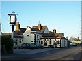
The Golden Ball Pub, Sittingbourne
On 81 Church Road.
Image: © David Anstiss
Taken: 4 Dec 2008
0.08 miles
9
Parapet of a railway bridge
This carried Church Road over a railway, of which there is no trace today, that was used by a company called Smeed Dean, formed in 1875 for the production of bricks http://miltoncreekmemories.co.uk/bricks/ Beyond the parapet, a car is about to emerge from Sunny Bank.
Image: © John Baker
Taken: 27 Jul 2014
0.09 miles
10
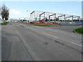
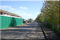
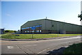
Construction sites, Castle Road Eurolink
The nearer building, under construction (reference 9a-9c) was granted planning permission by Swale Borough Council under application number 14/502471/FULL for the “proposed removal of 2 storey temporary accommodation. Construction of new amenity building with offices over, new fettling shop and replacement and enlarged storage area”. The further building under construction (described in the application as land north of Johnston Sweepers) was granted planning permission by Swale Borough Council under application number 15/509195/FULL for the “erection of 18 industrial units to be used within the B1/B2/B8 use classes with two associated vehicle accesses”. Note: when searching for development sites, on Swale Borough Council’s website for this road, it is important to add Eurolink, otherwise one ends up elsewhere!
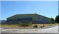
This image of Image shows how the view had changed 7 months later.
Image: © John Baker
Taken: 2 Apr 2017
0.09 miles