IMAGES TAKEN NEAR TO
Church Road, SITTINGBOURNE, ME10 3NL
Introduction
This page details the photographs taken nearby to Church Road, ME10 3NL by members of the Geograph project.
The Geograph project started in 2005 with the aim of publishing, organising and preserving representative images for every square kilometre of Great Britain, Ireland and the Isle of Man.

There are currently over 7.5m images from over14,400 individuals and you can help contribute to the project by visiting https://www.geograph.org.uk
Image Map
Images are licensed for reuse under creativecommons.org/licenses/by-sa/2.0
Notes
- Clicking on the map will re-center to the selected point.
- The higher the marker number, the further away the image location is from the centre of the postcode.
Image Listing (23 Images Found)
Images are licensed for reuse under creativecommons.org/licenses/by-sa/2.0
Image
Details
Distance

9
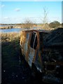
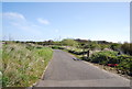
Burnt-out van near bridleway
Near Little Murston Nature Reserve. On bridleway from Sittingbourne to the Swale.
Image: © David Anstiss
Taken: 4 Dec 2008
0.17 miles
10
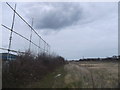
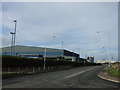
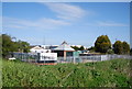
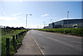
Footpath to Swale Way, Sittingbourne
This path leads from Meres Court Farm, past Bourne Park (football ground of Sittingbourne F.C. - on the left). On the right, is an empty plot of Eurolink East Industrial Estate.
This path is also used by the Swale Heritage Trail heading towards The Swale and Little Murston Nature Reserve.
Image: © David Anstiss
Taken: 16 Feb 2013
0.18 miles