IMAGES TAKEN NEAR TO
Rapson End, SITTINGBOURNE, ME10 3LW
Introduction
This page details the photographs taken nearby to Rapson End, ME10 3LW by members of the Geograph project.
The Geograph project started in 2005 with the aim of publishing, organising and preserving representative images for every square kilometre of Great Britain, Ireland and the Isle of Man.

There are currently over 7.5m images from over14,400 individuals and you can help contribute to the project by visiting https://www.geograph.org.uk
Image Map
Images are licensed for reuse under creativecommons.org/licenses/by-sa/2.0
Notes
- Clicking on the map will re-center to the selected point.
- The higher the marker number, the further away the image location is from the centre of the postcode.
Image Listing (93 Images Found)
Images are licensed for reuse under creativecommons.org/licenses/by-sa/2.0
Image
Details
Distance
1
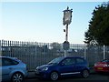
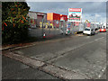
The Barge Pub, Sittingbourne
Was on 17 Crown Quay Lane, now demolished, only this sign exists.
Will probably turned into warehouse or office block as it is part of the Sittingbourne Industrial Park.
Image: © David Anstiss
Taken: 4 Dec 2008
0.03 miles
2
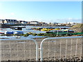
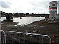
Development site, Crown Quay Lane
Planning permission has been granted by Swale Borough Council under application number 16/507877/FULL for the “erection of a residential development comprising 405 dwellings including associated access, parking, public open spaces and landscaping. New vehicular/pedestrian access from Eurolink Way and further secondary vehicular/pedestrian access off Crown Quay Lane. Associated drainage and earthworks”. The location was described as land to the west of Crown Quay Lane.
There is still an issue of flooding but a lot of rain had fallen in previous weeks, prior to this view.
This was the Image in October 2017.
Image: © John Baker
Taken: 23 Dec 2019
0.05 miles
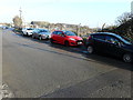
3
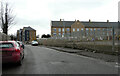
Crown Quay Lane
The newly-built houses lie in Seddingbourne Way, on an estate called Regent Quay.
Image: © John Baker
Taken: 1 Mar 2023
0.05 miles
4
A former ATS, Crown Quay Lane
The notice, beyond the forecourt, reads “Redrow land acquired for residential development”. Redrow is the name of a property developer.
Image: © John Baker
Taken: 17 Jan 2017
0.05 miles
5
Redrow, Crown Quay Lane
These premises used to be Image
Image: © John Baker
Taken: 2 Dec 2018
0.05 miles
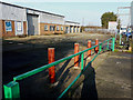
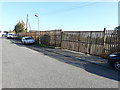
6
Derelict site, Crown Quay Lane
Crown Quay Lane is a popular road for free parking if you can find a space!
Image: © John Baker
Taken: 17 Jan 2017
0.06 miles
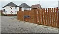
7
Derelict site, Crown Quay Lane
The wire fence of the Image has been replaced by a smart, new wooden one.
Image: © John Baker
Taken: 3 Oct 2017
0.06 miles
8
Seddingbourne Way
Part of a housing estate called Regent Quay.
Image: © John Baker
Taken: 1 Mar 2023
0.08 miles
9
Proposed development site, Crown Quay Lane
Planning permission has been granted by Swale Borough Council under application number 16/507877/FULL for the “erection of a residential development comprising 405 dwellings including associated access, parking, public open spaces and landscaping. New vehicular/pedestrian access from Eurolink Way and further secondary vehicular/pedestrian access off Crown Quay Lane. Associated drainage and earthworks”. The location was described as land to the west of Crown Quay Lane.
This is the Image before any buildings were erected and the ground became so waterlogged, through rainfall, that a huge lake was formed.
Image: © John Baker
Taken: 2 Dec 2018
0.09 miles
10
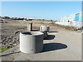
Proposed development site, Crown Quay Lane
Planning permission has been granted by Swale Borough Council under application number 16/507877/FULL for the “erection of a residential development comprising 405 dwellings including associated access, parking, public open spaces and landscaping. New vehicular/pedestrian access from Eurolink Way and further secondary vehicular/pedestrian access off Crown Quay Lane. Associated drainage and earthworks”. The location was described as land to the west of Crown Quay Lane.
The site is bounded, along Crown Quay Lane, by a tall, steel fence but it was possible to angle the camera to get a clear view.
Image: © John Baker
Taken: 3 Oct 2017
0.09 miles