IMAGES TAKEN NEAR TO
Plummer Crescent, SITTINGBOURNE, ME10 3FH
Introduction
This page details the photographs taken nearby to Plummer Crescent, ME10 3FH by members of the Geograph project.
The Geograph project started in 2005 with the aim of publishing, organising and preserving representative images for every square kilometre of Great Britain, Ireland and the Isle of Man.

There are currently over 7.5m images from over14,400 individuals and you can help contribute to the project by visiting https://www.geograph.org.uk
Image Map
Images are licensed for reuse under creativecommons.org/licenses/by-sa/2.0
Notes
- Clicking on the map will re-center to the selected point.
- The higher the marker number, the further away the image location is from the centre of the postcode.
Image Listing (20 Images Found)
Images are licensed for reuse under creativecommons.org/licenses/by-sa/2.0
Image
Details
Distance
1
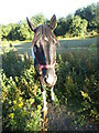
Friendly horse by Tonge Road, Snipeshill
Image: © David Howard
Taken: 17 Jul 2016
0.05 miles
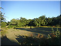
8

Eveas Drive, Great Easthall Estate
As seen from the junction with Mulberry Way.
Image: © David Anstiss
Taken: 16 Feb 2013
0.08 miles
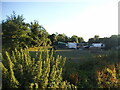
9
Mulberry Road, Great East Hall
This road leads towards the Great East Hall housing development (being built by Taylor Wimpey), from Oak Road. This entrance is only for buses (and cycles) heading towards the new houses. Cars from the estate may exit via this road. But the entrance to the estate is via Great East Hill Way (via Sittingbourne Industrial Estate).
Image: © David Anstiss
Taken: 5 Dec 2009
0.11 miles
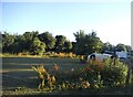
10
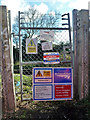
Railway access at 45 miles 76 chains
On the Victoria to Ramsgate line (VIR).
Image: © Robin Webster
Taken: 4 Apr 2015
0.12 miles