IMAGES TAKEN NEAR TO
Swale Way, SITTINGBOURNE, ME10 2UR
Introduction
This page details the photographs taken nearby to Swale Way, ME10 2UR by members of the Geograph project.
The Geograph project started in 2005 with the aim of publishing, organising and preserving representative images for every square kilometre of Great Britain, Ireland and the Isle of Man.

There are currently over 7.5m images from over14,400 individuals and you can help contribute to the project by visiting https://www.geograph.org.uk
Image Map
Images are licensed for reuse under creativecommons.org/licenses/by-sa/2.0
Notes
- Clicking on the map will re-center to the selected point.
- The higher the marker number, the further away the image location is from the centre of the postcode.
Image Listing (62 Images Found)
Images are licensed for reuse under creativecommons.org/licenses/by-sa/2.0
Image
Details
Distance
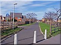
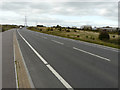
1
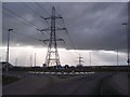
Roundabout on Swale Way
This roundabout is at the current end of Swale Way leading from The A249 Dual Carriageway to Kemsley Paper Mill (on access road on the left). This is about to change as the Sittingbourne Northern Relief Road is being built from here towards the Milton Creek.
Image: © David Anstiss
Taken: 16 Feb 2010
0.03 miles
2
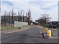
Entrance to Kemsley Mill
The photographer position is on a new roundabout, not yet shown on the map. The roundabout is part of the Sittingbourne northern relief road, which will eventually open up large areas north of Kemsley for further industrial development. Kemsley Mill is a paper mill.
Image: © Richard Dorrell
Taken: 2 Mar 2008
0.03 miles
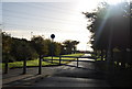
3
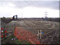
Construction of the Sittingbourne North Relief Road
As seen from Swale Way near Kemsley Paper Mill.
Image: © David Anstiss
Taken: 16 Feb 2010
0.03 miles
4
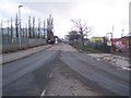
Access road to Kemsley Paper Mill
As seen from the roundabout on Swale Way.
Image: © David Anstiss
Taken: 16 Feb 2010
0.04 miles
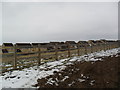
5
Former approach to Kemsley Mill
Access to Kemsley paper mill used to be through the village. A new road has now been built which bypasses the village completely, so the old road has become this footpath, and new housing has been built.
Image: © Richard Dorrell
Taken: 2 Mar 2008
0.08 miles
6
Kemsley
From the newly-constructed Sittingbourne Northern Relief Road.
Image: © Burgess Von Thunen
Taken: 8 Feb 2012
0.08 miles
7
Ridham Avenue
This path leads to Ridham Avenue road leading from Coldharbour Lane. Seen from Swale Way.
Image: © David Anstiss
Taken: 16 Feb 2010
0.10 miles
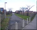
9

Recreation Way
2000s houses in Kemsley.
Image: © Burgess Von Thunen
Taken: 3 Jul 2012
0.10 miles
10
Employment development site, Swale Way (B2005)
Details about the site may be found on a Harrison chartered surveyors board, positioned to the right of the road and distantly seen in this image. It reads: under offer, employment development site, approx 3.54 ha (8.75 acres), planning for up to 8000 sq m, B1 and B2 users https://harrisons.property/property-details?id=144+1590&title=site-at-swale-way-(fulcrum-business-park)-kemsley-sittingbourne-kent
Planning permission has been granted by Swale Borough Council under application number 14/500327/OUT for an “outline (access not reserved) - up to 8000m2 of Class B1 and B2 floor space and all necessary supporting infrastructure including roads, parking, open space, amenity landscaping, biodiversity enhancement and buffer to proposed extension to Milton Creek Country Park. Detailed approval for Phase 1 including (i) vehicular and pedestrian access to Swale Way; (ii) 30 space (approximately) informal car park to serve extension to Milton Creek Country Park; Change of use of approximately 13.31 ha of Kemsley Marshes as an extension to Milton Creek Country Park with footpath connections to the proposed informal car park”.
Image: © John Baker
Taken: 3 Oct 2017
0.11 miles