IMAGES TAKEN NEAR TO
Saxon Shore, SITTINGBOURNE, ME10 2UP
Introduction
This page details the photographs taken nearby to Saxon Shore, ME10 2UP by members of the Geograph project.
The Geograph project started in 2005 with the aim of publishing, organising and preserving representative images for every square kilometre of Great Britain, Ireland and the Isle of Man.

There are currently over 7.5m images from over14,400 individuals and you can help contribute to the project by visiting https://www.geograph.org.uk
Image Map
Images are licensed for reuse under creativecommons.org/licenses/by-sa/2.0
Notes
- Clicking on the map will re-center to the selected point.
- The higher the marker number, the further away the image location is from the centre of the postcode.
Image Listing (62 Images Found)
Images are licensed for reuse under creativecommons.org/licenses/by-sa/2.0
Image
Details
Distance
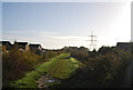
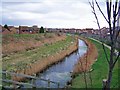
2
Footbridge over Marsh Stream
Footpath from Beauvoir Drive (unseen, other side of embankment) leads to playing field (just to right of photo) at end of Eadred Way. Stream and embankment footpath leads to Grovehurst Road, they are part of Church Marshes Country Park, which is open land on the Swale.
Image: © David Anstiss
Taken: 17 Dec 2008
0.03 miles
3
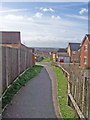
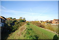
Footpath to Church Milton
Until recently, this footpath crossed an open field. Now it follows its original line through the middle of a housing estate.
Image: © Richard Dorrell
Taken: 2 Mar 2008
0.04 miles
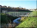
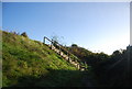
7
New bridge and steps
This new bridge was built when the Kemsley housing estate was built (out of the photo on the right). The footpath used to cross an open field, and a wooden plank was then considered sufficient to bridge the drain at this point. The houses behind the flood bund are in the Church Milton development.
Image: © Richard Dorrell
Taken: 2 Mar 2008
0.06 miles
9

Kemsley Marshes
Drainage in Kemsley.
Image: © Burgess Von Thunen
Taken: 3 Jul 2012
0.06 miles
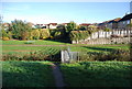
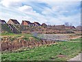
10
Drain and flood bund, plus new housing
This drain and the raised bank alongside it, which is a flood bund, have been here for years. The housing on the left was built about 15 years ago, while the housing on the right is much more recent.
Image: © Richard Dorrell
Taken: 2 Mar 2008
0.06 miles