IMAGES TAKEN NEAR TO
Eclipse Drive, SITTINGBOURNE, ME10 2HR
Introduction
This page details the photographs taken nearby to Eclipse Drive, ME10 2HR by members of the Geograph project.
The Geograph project started in 2005 with the aim of publishing, organising and preserving representative images for every square kilometre of Great Britain, Ireland and the Isle of Man.

There are currently over 7.5m images from over14,400 individuals and you can help contribute to the project by visiting https://www.geograph.org.uk
Image Map
Images are licensed for reuse under creativecommons.org/licenses/by-sa/2.0
Notes
- Clicking on the map will re-center to the selected point.
- The higher the marker number, the further away the image location is from the centre of the postcode.
Image Listing (17 Images Found)
Images are licensed for reuse under creativecommons.org/licenses/by-sa/2.0
Image
Details
Distance
1
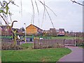
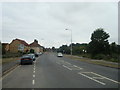
Modern housing in Milton Regis
Four cul-de-sacs end at a grassy area and Eleanor Drive children's playground. The wooden footbridge crosses a drainage ditch. To the right is the Sittingbourne to Sheerness railway line.
Image: © Richard Dorrell
Taken: 4 Apr 2008
0.06 miles
2
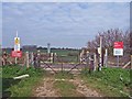
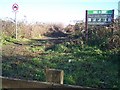
Farm track level crossing
This padlocked crossing looks very rural, but immediately behind the photographer's position is a modern housing estate.
Image: © Richard Dorrell
Taken: 4 Apr 2008
0.11 miles
3
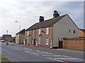
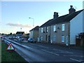
Blue Houses, Grovehurst Road
This row of cottages and the house beyond are now the only older buildings among a sea of modern housing. The cottages are numbers 1 to 4, "Blue Houses".
Image: © Richard Dorrell
Taken: 4 Apr 2008
0.12 miles
6
Entrance to Church Marshes Country Park
On Grovehurst Road. Follows line of drainage stream towards the Swale, where the park opens up.
Image: © David Anstiss
Taken: 17 Dec 2008
0.17 miles
7
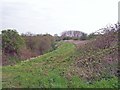
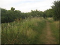
Footpath to Church Marshes Country Park
This path follows the drainage channel (almost dry in this picture) round the flood bund to the newly created Church Marshes Country Park.
Image: © Richard Dorrell
Taken: 4 Apr 2008
0.17 miles
8
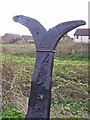
National Cycle Network milepost
The National Cycle Network was created by the Millennium Project Commission. This milepost is one of 1000 which were funded by the Royal Bank of Scotland.
Image: © Richard Dorrell
Taken: 4 Apr 2008
0.17 miles
10
Footpath beside Kemsley Marsh dyke
This path leads from Grovehurst Road towards Newman Drive and onwards towards Church Marshes Country Park. The dyke leads also into the country park and towards the Milton Creek.
Image: © David Anstiss
Taken: 30 Jun 2010
0.20 miles