IMAGES TAKEN NEAR TO
Monarch Drive, SITTINGBOURNE, ME10 2GR
Introduction
This page details the photographs taken nearby to Monarch Drive, ME10 2GR by members of the Geograph project.
The Geograph project started in 2005 with the aim of publishing, organising and preserving representative images for every square kilometre of Great Britain, Ireland and the Isle of Man.

There are currently over 7.5m images from over14,400 individuals and you can help contribute to the project by visiting https://www.geograph.org.uk
Image Map (Loading...)


Getting Data...Please wait
Leaflet Map data © OpenStreetMap
Images are licensed for reuse under creativecommons.org/licenses/by-sa/2.0
Notes
- Clicking on the map will re-center to the selected point.
- The higher the marker number, the further away the image location is from the centre of the postcode.
Image Listing (30 Images Found)
Images are licensed for reuse under creativecommons.org/licenses/by-sa/2.0
Image
Details
Distance
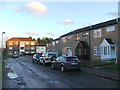
1
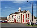
The Kemsley Arms public house
In recent years, the Kemsley Arms has struggled to stay open. Much new housing in the area has improved its chances of survival, but it still has a dubious reputation from the past to live down.
Image: © Richard Dorrell
Taken: 2 Mar 2008
0.05 miles
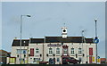
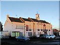
3
Kemsley Village Hall
The hall was hosting a meeting of the New Covenant Church when this picture was taken on a Sunday morning. Gospel singing was issuing from within.
Image: © Richard Dorrell
Taken: 2 Mar 2008
0.06 miles
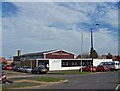
7
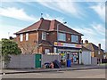
Village Stores, Kemsley
A traditional "corner shop" now serving an expanding community.
Image: © Richard Dorrell
Taken: 2 Mar 2008
0.08 miles

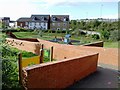
9
Railway to Sittingbourne
As seen from Image This line leads from the Isle of Sheppey (Sheerness and Queenborough Stations) to Sittingbourne via Kemsley.
More houses for Kemsley are being built on the left. In the background (along the line) is Hurst Lane footbridge.
Image: © David Anstiss
Taken: 16 Feb 2010
0.10 miles
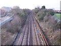
10
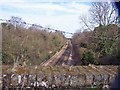
Sittingbourne to Sheerness branch line
Looking north from a former road bridge, now used only as a footbridge, in Hurst Lane. The new bridge in the distance carries the Sittingbourne Northern Relief Road.
Image: © Richard Dorrell
Taken: 2 Mar 2008
0.11 miles