IMAGES TAKEN NEAR TO
Frederick Street, SITTINGBOURNE, ME10 1BG
Introduction
This page details the photographs taken nearby to Frederick Street, ME10 1BG by members of the Geograph project.
The Geograph project started in 2005 with the aim of publishing, organising and preserving representative images for every square kilometre of Great Britain, Ireland and the Isle of Man.

There are currently over 7.5m images from over14,400 individuals and you can help contribute to the project by visiting https://www.geograph.org.uk
Image Map
Images are licensed for reuse under creativecommons.org/licenses/by-sa/2.0
Notes
- Clicking on the map will re-center to the selected point.
- The higher the marker number, the further away the image location is from the centre of the postcode.
Image Listing (154 Images Found)
Images are licensed for reuse under creativecommons.org/licenses/by-sa/2.0
Image
Details
Distance
4
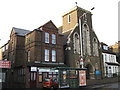
Religious Buildings on the A2 London Road
Sittingbourne Islamic Cultral Centre is beside the Church of the Sacred Heart of Jesus.
See http://www.sacredheartrcchurch.org.uk/ for more details about the church
Image: © David Anstiss
Taken: 6 Nov 2010
0.05 miles
10
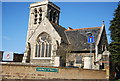
Holy Trinity Church
Grade II listed. http://www.britishlistedbuildings.co.uk/en-501887-church-of-the-holy-trinity-sittingbourne
Image: © N Chadwick
Taken: 22 Apr 2012
0.09 miles