IMAGES TAKEN NEAR TO
Pleasant View, MANCHESTER, M9 8WJ
Introduction
This page details the photographs taken nearby to Pleasant View, M9 8WJ by members of the Geograph project.
The Geograph project started in 2005 with the aim of publishing, organising and preserving representative images for every square kilometre of Great Britain, Ireland and the Isle of Man.

There are currently over 7.5m images from over14,400 individuals and you can help contribute to the project by visiting https://www.geograph.org.uk
Image Map
Images are licensed for reuse under creativecommons.org/licenses/by-sa/2.0
Notes
- Clicking on the map will re-center to the selected point.
- The higher the marker number, the further away the image location is from the centre of the postcode.
Image Listing (38 Images Found)
Images are licensed for reuse under creativecommons.org/licenses/by-sa/2.0
Image
Details
Distance
1
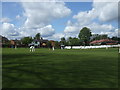
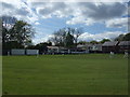
Blackley Cricket Club
The cottages and scorebox at Blackley CC's Crab Lane Ground. The club play in the North Manchester Cricket League.
Image: © BatAndBall
Taken: 12 May 2012
0.01 miles
2
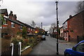
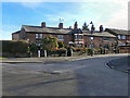
Crab Lane, Higher Blackley
Most of these houses were threatened with demolition about 30 years ago, but won a reprieve. They are now in a conservation area.
Image: © Bill Boaden
Taken: 13 Mar 2010
0.02 miles
3
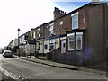
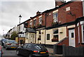
Flying Horse
The Flying Horse public house occupies most of this row of terraced houses on Crab Lane in Higher Blackley.
Image: © David Dixon
Taken: 8 Feb 2011
0.03 miles
4
Flying Horse
The Flying Horse public house on Crab Lane, Higher Blackley
Image: © David Dixon
Taken: 8 Feb 2011
0.03 miles
5
Blackley Cricket Club
The Clubhouse at Blackley CC's Crab Lane ground.
Image: © BatAndBall
Taken: 12 May 2012
0.04 miles
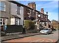
6
The Flying Horse, Crab Lane
This was always a good community local. It used to be part of the Boddington's chain, but I see it is now a free house.
Image: © Bill Boaden
Taken: 13 Mar 2010
0.04 miles
7
Crab Lane, Higher Blackley
Terraced housing on Crab Lane, at the corner with Longhurst Road, Higher Blackley.
Image: © David Dixon
Taken: 8 Feb 2011
0.05 miles
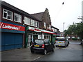
8
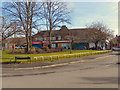
Higher Blackley Shops
Row of shops, set back from Victoria Avenue at the junction with Tweedle Hill Road. The Spar shop in the centre of the row is also Higher Blackley Post Office.
Image: © David Dixon
Taken: 8 Feb 2011
0.07 miles
9
Post Office and shop on Victoria Avenue, Manchester
Image: © JThomas
Taken: 17 Sep 2018
0.07 miles
10
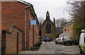
Churchdale Road and St Andrew's Church
The church was built in 1865 following donations by the local lord of the manor, the Earl of Wilton.
Image: © Bill Boaden
Taken: 13 Mar 2010
0.07 miles