IMAGES TAKEN NEAR TO
Waters Edge Business Park, Modwen Road, SALFORD, M5 3EZ
Introduction
This page details the photographs taken nearby to Waters Edge Business Park, Modwen Road, M5 3EZ by members of the Geograph project.
The Geograph project started in 2005 with the aim of publishing, organising and preserving representative images for every square kilometre of Great Britain, Ireland and the Isle of Man.

There are currently over 7.5m images from over14,400 individuals and you can help contribute to the project by visiting https://www.geograph.org.uk
Image Map
Images are licensed for reuse under creativecommons.org/licenses/by-sa/2.0
Notes
- Clicking on the map will re-center to the selected point.
- The higher the marker number, the further away the image location is from the centre of the postcode.
Image Listing (205 Images Found)
Images are licensed for reuse under creativecommons.org/licenses/by-sa/2.0
Image
Details
Distance
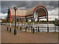
1
Manchester Ship Canal, Ivy Wharf
Ivy Wharf is part of the Irwell River Park http://www.irwellriverpark.com/assets/files/Irwell%20Park%20Overview.pdf (pdf document), opposite the former Pomona Docks.
Image: © David Dixon
Taken: 1 Oct 2012
0.04 miles
2
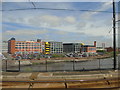
The Soapworks
This is the Soapworks, a re-development of the former Colgate Palmolive Factory across the Manchester Ship Canal from Pomona Docks, Salford, Greater Manchester, as seen from the tram (line serving MediaCityUK and Eccles).
Image: © Carroll Pierce
Taken: 5 Jun 2018
0.06 miles
3
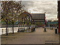
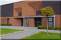
Waters Edge Business Park
Towpath alongside Waters Edge Business Park.
Image: © Peter McDermott
Taken: 25 Jan 2015
0.06 miles
4
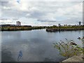
Pomona Dock #3
On the left is the Manchester Ship Canal. On the right is Pomona Dock #3 from where a lock allows entry to the Bridgewater Canal for permitted vessels.
Image: © Gerald England
Taken: 23 Aug 2017
0.06 miles
5
Manchester Ship Canal, Ivy Wharf and Pomona Docks
Ivy Wharf is part of the Irwell River Park http://www.irwellriverpark.com/assets/files/Irwell%20Park%20Overview.pdf (pdf document). It is opposite the former Pomona Docks; in this photograph, the remains of Dock number 3 can be seen on the opposite side of the canal.
Image: © David Dixon
Taken: 1 Oct 2012
0.06 miles
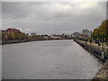
6
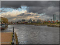
Pomona Docks
Pomona Docks with Manchester City Centre in the background.
Image: © Peter McDermott
Taken: 22 Apr 2017
0.06 miles
7
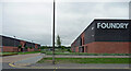
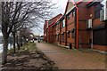
Foundry, Ordsall Lane, Salford
A business park built on brownfield land by the Manchester Ship Canal in the early 2010s. Quite interestingly designed (Image]).
Image: © Stephen Richards
Taken: 29 May 2017
0.06 miles
8
Pomona Docks, Manchester Ship Canal
Looking along the Manchester Ship Canal towards the Manchester and Salford city centres, from Salford Quays/Trafford Park.
For more information about the docks, see http://en.wikipedia.org/wiki/Pomona_Docks#Pomona_Docks
Image: © David Dixon
Taken: 14 Sep 2012
0.07 miles
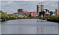
10
Manchester Ship Canal
Looking along the canal, from Ivy Wharf, towards Manchester and Salford city centres. The tallest building (towards the right hand side of the photograph) is Image], a 47-storey hotel and apartment building. The remains of Pomona Docks (numbers 3 and 2) can be seen on the right hand side of the canal as we look at it.
Image: © David Dixon
Taken: 1 Oct 2012
0.08 miles