IMAGES TAKEN NEAR TO
Taunton Street, MANCHESTER, M4 7FA
Introduction
This page details the photographs taken nearby to Taunton Street, M4 7FA by members of the Geograph project.
The Geograph project started in 2005 with the aim of publishing, organising and preserving representative images for every square kilometre of Great Britain, Ireland and the Isle of Man.

There are currently over 7.5m images from over14,400 individuals and you can help contribute to the project by visiting https://www.geograph.org.uk
Image Map
Images are licensed for reuse under creativecommons.org/licenses/by-sa/2.0
Notes
- Clicking on the map will re-center to the selected point.
- The higher the marker number, the further away the image location is from the centre of the postcode.
Image Listing (217 Images Found)
Images are licensed for reuse under creativecommons.org/licenses/by-sa/2.0
Image
Details
Distance
1

Footpath off Every Street
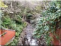
A footpath above the River Medlock.
Image: © Gerald England
Taken: 2 Mar 2013
0.03 miles
2

River Medlock
Looking downstream from the bridge at Ashton New Road
Image: © David Dixon
Taken: 19 May 2010
0.05 miles
3
Every Street in Manchester
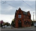
I've been to Every Street in Manchester. The unusual named street runs from the A662 (Ashton New Road/Merril Street) to Great Ancoats Street. Merril Street is presently closed to road works and buses are being diverted down Every Street. The building on the corner was formerly the District Bank.
Image: © Gerald England
Taken: 28 Sep 2009
0.05 miles
4
Merrill Street
Taken from the top deck of a bus. Ahead is Merril Street Image which is the A662 to Ancoats. The road has been closed for the laying of the Metrolink tramlines to Droylsden and Ashton under Lyne. All traffic is now diverted along Every Street.
Image: © Gerald England
Taken: 6 Sep 2010
0.05 miles
5
River Medlock
From the Ashton New Road bridge.
Image: © Gerald England
Taken: 28 Sep 2009
0.05 miles
6

Merrill Street, Holt Town
The A662 from Droylsden. Since Merrill Street is now used by the Metrolink trams, bus services travel down Every Street on the left instead. The building on the corner was originally the District Bank.
Image: © Gerald England
Taken: 5 Aug 2015
0.05 miles
7
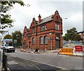
Former District Bank on Every Street
The building on the corner of Every Street and Merrill Street was originally the District Bank which merged into the Natwest in 1970. Carved in stone above the shuttered corner door are the coat of arms Image bearing the Latin motto, "Decus Prudentia Merces" which translates as "A Reward and Honour to Prudence". This is the coat of arms for the bank. It has a small car park at the back and appears to be currently in use as an office of some description.
On the left further down Every Street can be seen the former All Soul's Church Image
Image: © Gerald England
Taken: 7 May 2016
0.05 miles
8
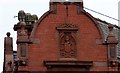
District Bank coat of arms
Carved in stone above the corner face of the former District Bank Image are the coat of arms bearing the Latin motto, "Decus Prudentia Merces" which translates as "A Reward and Honour to Prudence". This is the coat of arms for the bank. At the sides are small grotesques.
Image: © Gerald England
Taken: 7 May 2016
0.05 miles
9
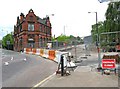
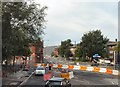
Junction of Merrill Street & Every Street
Merrill Street, on the right, was closed off for many weeks to allow the installation of tramway track for the extension of the Manchester Metrolink to Droylsden. Later it will be extended to Ashton-under-Lyne.
Image: © P L Chadwick
Taken: 2 May 2010
0.06 miles
10
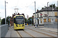
Tram leaving Holt Town stop
The Mitchell Arms to the right is completely boarded up.
Image: © Alan Murray-Rust
Taken: 7 Aug 2013
0.06 miles