IMAGES TAKEN NEAR TO
Naples Street, MANCHESTER, M4 4BJ
Introduction
This page details the photographs taken nearby to Naples Street, M4 4BJ by members of the Geograph project.
The Geograph project started in 2005 with the aim of publishing, organising and preserving representative images for every square kilometre of Great Britain, Ireland and the Isle of Man.

There are currently over 7.5m images from over14,400 individuals and you can help contribute to the project by visiting https://www.geograph.org.uk
Image Map
Images are licensed for reuse under creativecommons.org/licenses/by-sa/2.0
Notes
- Clicking on the map will re-center to the selected point.
- The higher the marker number, the further away the image location is from the centre of the postcode.
Image Listing (994 Images Found)
Images are licensed for reuse under creativecommons.org/licenses/by-sa/2.0
Image
Details
Distance
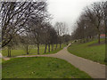
1
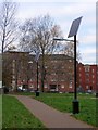
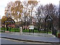
Here comes the sun.
Solar powered street lighting along a path at Angel Meadow and St Michael's Flags.
http://en.wikipedia.org/wiki/St_Michael%27s_Flags_and_Angel_Meadow_Park
Image: © Keith Williamson
Taken: 14 Dec 2005
0.03 miles
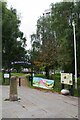
2
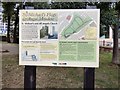
St Michael's Flags & Angel Meadow
Information board near the entrance on Angel Street.
Angel Meadow was consecrated in 1787 to serve the grossly overcrowded Angel Meadow area and was the largest cemetery in Manchester. Next to the Parochial Burial Ground St Michael's and All Angels Church was built in 1788 and stood until 1935. It was used for burying paupers who had no money for a proper burial. By 1816 the burial ground was full and closed down. Covered in flagstones, it then became a children's playground known as "St Michael's Flags". The flags remained in place until they were removed in 2001 when the site was renovated to create the park we see today.
More information and photos at Manchester History Net http://manchesterhistory.net/manchester/tours/tour16/area16page8.html and Friends of Angel Meadow http://www.friends-of-angel-meadow.org/page26.htm
Image: © Gerald England
Taken: 5 Sep 2018
0.03 miles
3
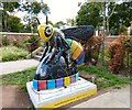
Cottonopolis
Located at the side of Angel Street, next to the steps leading to Angel Meadow, Cottonopolis was created by Leah Pendleton and sponsored by Meadow Side.
"The design focuses on Manchester’s industrial heritage and is a visual metaphor for the way cotton is woven into the fabric of the city. The black background alludes to the smoky skies that hung over Manchester in its 'Cottonopolis' heyday. The patterns appear to have a woven, tactile texture whilst pools of bold, coloured cotton weave around the shape of the Bee."
MeadowSide is a mix of apartments, townhouses and penthouses on the edge of the park.
Image: © Gerald England
Taken: 5 Sep 2018
0.03 miles
4
Angel Meadow
Angel Meadow was consecrated in 1787 to serve the grossly overcrowded Angel Meadow area and was the largest cemetery in Manchester. Next to the Parochial Burial Ground St Michael's and All Angels Church was built in 1788 and stood until 1935. It was used for burying paupers who had no money for a proper burial. By 1816 the burial ground was full and closed down. Covered in flagstones, it then became a children's playground known as "St Michael's Flags". The flags remained in place until they were removed in 2001 when the site was renovated to create the park we see today.
More information and photos at Manchester History Net http://manchesterhistory.net/manchester/tours/tour16/area16page8.html and Friends of Angel Meadow http://www.friends-of-angel-meadow.org/page26.htm
Image: © Gerald England
Taken: 5 Sep 2018
0.03 miles
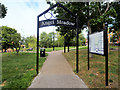
5
Angel Meadow and St Michael's Flags
Situated in Manchester's Northern Quarter, not far from the Cathedral, this pleasant green area has an interesting history, told on information boards around the site. Once the site of a church, a pauper's/plague burial ground and, reputedly, Manchester's worst slums. An estimated 40,000 bodies were buried here between 1787 and 1816. Some details here: http://en.wikipedia.org/wiki/St_Michael's_Flags_and_Angel_Meadow_Park
Image: © Keith Williamson
Taken: 14 Dec 2005
0.03 miles
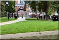
6
St Michaels Flags
The St Michaels gate to an urban park. See also Image and read about its history at https://en.wikipedia.org/wiki/St_Michael%27s_Flags_and_Angel_Meadow_Park
Image: © Glyn Baker
Taken: 10 Sep 2021
0.03 miles
7
Angel Meadow
What is now a pleasant city park between Aspin Lane and Old Mount Street was once the churchyard of St Michael's and All Angels Church which was built in 1788 and stood until 1935. It was originally built as a carriage church for wealthy Mancunians from the town, or for those who had taken up residence in the more fashionable houses of the area. Prior to its construction the Overseers of the Poor of Manchester had purchased the land adjoining the churchyard for use as a parochial Burial Ground to cater for the high rates of mortality that resulted from the overcrowded slum conditions of the area; a big influence on the philosopher Friedrich Engels who famously wrote about the pauper burial grounds in Manchester in his account of the Condition of the Working Classes in England (1844).
The “new Burying Ground”, or “The Flags” as it later became known, was consecrated in 1787 to serve the grossly overcrowded Angel Meadow area and was the largest cemetery in Manchester. It was used for burying paupers who had no money for a proper burial. By 1816 the burial ground was full and closed down. Covered in flagstones, it then became a children's playground known as “St Michael’s Flags”. It has been estimated that there were more than 40000 bodies beneath the flags which remained in place until they were removed in 2001 when the site was renovated to create the park we see today.
More information and photos at Manchester History Net http://manchesterhistory.net/manchester/tours/tour16/area16page8.html and Wikipedia http://en.wikipedia.org/wiki/St_Michael's_Flags_and_Angel_Meadow_Park .
Image: © David Dixon
Taken: 6 Aug 2018
0.04 miles
8
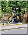
Cottonopolis, Angel Meadow
Cottonopolis is bee#14 in the Bee in the City sculpture trail, It is positioned at the side of Angel Street, next to the steps leading to Angel Meadow. The design, created by Leah Pendleton, focuses on Manchester’s industrial heritage and is intended to be “a visual metaphor for the way cotton is woven into the fabric of the city”. The black background alludes to the smoky skies that hung over Manchester in its ‘Cottonopolis’ heyday. The patterns appear to have a woven, tactile texture whilst pools of bold, coloured cotton weave around the shape of the bee.
Image: © David Dixon
Taken: 6 Aug 2018
0.04 miles
9
Angel Meadow/St Michael's Flags
This pleasant city park between Aspin Lane and Old Mount Street is divided by an old wall. The land between this wall and Angel Street was once the churchyard of St Michael's and All Angels Church which was built in 1788 and stood until 1935. The rest of the land was the Parochial Burial Ground.
The “new Burying Ground”, or “The Flags” as it later became known, was consecrated in 1787 to serve the grossly overcrowded Angel Meadow area and was the largest cemetery in Manchester. It was used for burying paupers who had no money for a proper burial. By 1816 the burial ground was full and closed down. Covered in flagstones, it then became a children's playground known as “St Michael’s Flags”. The flags remained in place until they were removed in 2001 when the site was renovated to create the park we see today. More information and photos at Manchester History Net http://manchesterhistory.net/manchester/tours/tour16/area16page8.html and Wikipedia http://en.wikipedia.org/wiki/St_Michael's_Flags_and_Angel_Meadow_Park .
Image: © David Dixon
Taken: 15 Mar 2012
0.04 miles
10
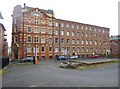
Manchester, CWS Printing Works
On New Mount Street, later transferring to Longsight; now residential and business units. http://manchesterhistory.net/manchester/tours/tour12/coopprint.html
Image: © Mike Faherty
Taken: 26 Dec 2014
0.04 miles