IMAGES TAKEN NEAR TO
Fairhills Road, MANCHESTER, M44 6BD
Introduction
This page details the photographs taken nearby to Fairhills Road, M44 6BD by members of the Geograph project.
The Geograph project started in 2005 with the aim of publishing, organising and preserving representative images for every square kilometre of Great Britain, Ireland and the Isle of Man.

There are currently over 7.5m images from over14,400 individuals and you can help contribute to the project by visiting https://www.geograph.org.uk
Image Map
Images are licensed for reuse under creativecommons.org/licenses/by-sa/2.0
Notes
- Clicking on the map will re-center to the selected point.
- The higher the marker number, the further away the image location is from the centre of the postcode.
Image Listing (29 Images Found)
Images are licensed for reuse under creativecommons.org/licenses/by-sa/2.0
Image
Details
Distance
1
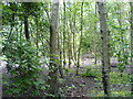
Woods
Woodland close to the Old River, Irlam. The Old River is a remnant of a bend of the River Irwell which was left after canalisation of the river to make the Manchester Ship Canal. See Image
Image: © Keith Williamson
Taken: 26 May 2007
0.08 miles
2

Pill Box
A relic of World War II, this pill box was located within the grounds of a CWS factory that occupied this site until the 1970s. The Cooperative Wholesale Society (CWS) operated several factories in this locality (a Wines and Spirits Depot, a Soap Works - site of this pill box-, a Glycerine, Starch and Candle Works and, a little further away, a Margarine Works). Also close by was Irlam Steelworks. Since taking this picture the pill box and surrounding area have been cleared to make way for the construction small industrial/warehouse units. See Image
Image: © Keith Williamson
Taken: 14 May 2006
0.13 miles
3
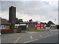
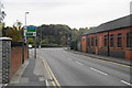
Irlam Fire Station
Located on Fairhills Road.
Image: © Keith Williamson
Taken: 18 Jun 2007
0.14 miles
4
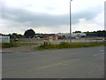
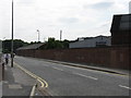
Site cleared
The long derelict site of a former CWS Soapworks has been cleared and levelled ready for the construction of a number of light industrial/warehouse units. See Image
Image: © Keith Williamson
Taken: 18 Jun 2007
0.15 miles
5
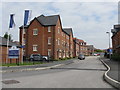
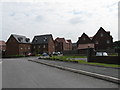
Irlam - Fairhills Point Housing Development
Image: © Peter Whatley
Taken: 4 Jun 2009
0.15 miles
6
The end of Fairhills Road, Irlam
It meets the A57 on its new route bypassing the centre of Irlam and Cadishead.
Image: © Bill Boaden
Taken: 2 Oct 2011
0.16 miles
8
Irlam - New Housing Off Fairhills Road
Image: © Peter Whatley
Taken: 4 Jun 2009
0.18 miles
10
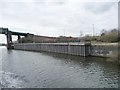
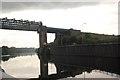
Ladder up to the A57, below Irlam locks
Sheet-piled north bank of the Manchester Ship Canal.
Image: © Christine Johnstone
Taken: 13 Apr 2013
0.20 miles