IMAGES TAKEN NEAR TO
Manchester Industrial Centre, Water Street, MANCHESTER, M3 4JW
Introduction
This page details the photographs taken nearby to Manchester Industrial Centre, Water Street, M3 4JW by members of the Geograph project.
The Geograph project started in 2005 with the aim of publishing, organising and preserving representative images for every square kilometre of Great Britain, Ireland and the Isle of Man.

There are currently over 7.5m images from over14,400 individuals and you can help contribute to the project by visiting https://www.geograph.org.uk
Image Map
Images are licensed for reuse under creativecommons.org/licenses/by-sa/2.0
Notes
- Clicking on the map will re-center to the selected point.
- The higher the marker number, the further away the image location is from the centre of the postcode.
Image Listing (745 Images Found)
Images are licensed for reuse under creativecommons.org/licenses/by-sa/2.0
Image
Details
Distance
1
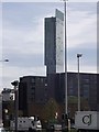
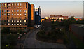
A little deception
Two recently constructed apartment buildings near Potato Wharf, Manchester. The one on the left was completed as the economy took a turn for the worse. Work on the rightmost building was stopped while it was still a concrete "skeleton". What seems to be brick and glass is in fact a printed fabric cover stretched around the frame and improving its appearance! The Beetham Tower/ Hilton Hotel dominates the background.
Image: © Keith Williamson
Taken: 6 Apr 2011
0.01 miles
2
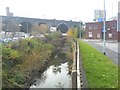
River Medlock
The River Medlock rises in Oldham, to the north east of Manchester and flows through east Manchester into the city centre. Within the city much of its course is culverted under buildings etc., the river only briefly appearing where it flows below bridges carrying the roads and railways of the city. Pictured here is part of a lengthy exposed stretch of the river as it flows alongside Potato Wharf, Castlefield (on the left bank) and the New Elm Road industrial area (to the right). In the distance the river flows under the Dawson Street road bridge and then adds its waters to the River Irwell.
Image: © Keith Williamson
Taken: 6 Nov 2008
0.02 miles
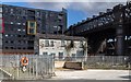
3
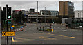
Trinity Way
Junction of Trinity Way with Regent Road.
Image: © Peter McDermott
Taken: 29 Mar 2020
0.05 miles
4

Robins & Day
Rear of the old Robins & Day garage.
Image: © Peter McDermott
Taken: 1 Oct 2017
0.06 miles
5
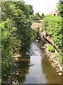
River Medlock
A surprise view of the river which is largely subterranean in this area. Here it emerges from a tunnel beneath the Castlefield canal basin and Potato Wharf, where there is a weir Image The tunnel was constructed to avoid the grossly-polluted water entering the canal except under flood conditions. The water quality has obviously improved dramtically as there is a heron fishing very successfully, and two swans enjoying the cool shade.
Image: © Jonathan Wilkins
Taken: 27 Jun 2010
0.06 miles
6
Potato Wharf
Flats on Potato Wharf in the Castlefield area of Manchester.
Image: © Peter McDermott
Taken: 23 Jul 2014
0.07 miles
7
Concrete Supply Depot
Concrete supply depot in the Castlefield area of central Manchester.
Image: © Peter McDermott
Taken: 19 Apr 2015
0.07 miles
8
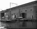
Hulme Lock, Bridgewater Canal, Manchester.
On the north side of the canal is seen Hulme Lock, the top one of three that led down from the Bridgewater Canal to the Manchester Ship Canal. Very little use was made of it latterly, as pleasure boats are not normally allowed onto the Ship Canal, and barge traffic had ceased by 1981 when this was taken. These locks are now closed and have been replaced by an alternative arrangement. Above the water is seen the railway which later became part of Manchester's tram system.
Image: © Dr Neil Clifton
Taken: 12 Apr 1981
0.07 miles
9
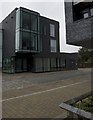
Potato Wharf, Manchester
Apartment development in the Castlefield area
Image: © Paul Harrop
Taken: 5 Aug 2011
0.07 miles