IMAGES TAKEN NEAR TO
Churchfields, MANCHESTER, M34 5HZ
Introduction
This page details the photographs taken nearby to Churchfields, M34 5HZ by members of the Geograph project.
The Geograph project started in 2005 with the aim of publishing, organising and preserving representative images for every square kilometre of Great Britain, Ireland and the Isle of Man.

There are currently over 7.5m images from over14,400 individuals and you can help contribute to the project by visiting https://www.geograph.org.uk
Image Map
Images are licensed for reuse under creativecommons.org/licenses/by-sa/2.0
Notes
- Clicking on the map will re-center to the selected point.
- The higher the marker number, the further away the image location is from the centre of the postcode.
Image Listing (178 Images Found)
Images are licensed for reuse under creativecommons.org/licenses/by-sa/2.0
Image
Details
Distance
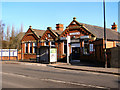
1
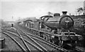
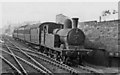
Up freight at Stockport Junction, Guide Bridge
View westward, towards Manchester (London Road and Central) on the ex-Great Central main line Manchester - Sheffield. Curving to the left is the ex-London & North Western line to Stockport, while to the right behind the train is the Joint line to Ashton and Oldham: Guide Bridge was a very important and busy junction on the east side of Manchester. The train is headed by ex-GC Robinson O4 2-8-0 No. 63743 - evidently recently overhauled.
Image: © Ben Brooksbank
Taken: 27 Oct 1951
0.04 miles
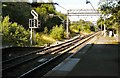
2
Guide Bridge West Junction
The remaining connection at the west end of the station, leading off to Stockport. Until the early 1980s, this was a four-track railway, with multi-track junctions both left and right, all busy with freight. Recession, heavy industry's decline and catastrophic railway strikes in 1982 and 1984 changed the infrastructure utterly. For a view 25 years on, see: http://www.geograph.org.uk/photo/3676972.
Image: © Peter Whatley
Taken: 2 Jul 1988
0.05 miles
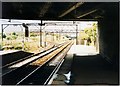
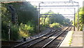
3
Guide Bridge West Junction
The remaining connection at the west end of the station, leading off to Stockport. Until the early 1980s, this was a four-track railway, with multi-track junctions both left and right, all busy with freight. Now the main line goes through to Manchester Piccadilly. The left fork is still used for freight and once a week only carries a service from Stockport to Stalybridge calling at Reddish South and Denton.
View this junction in 1988: Image
Image: © Gerald England
Taken: 16 Aug 2010
0.05 miles
5
Local train from Oldham and Ashton approaching Guide Bridge station
The train has come off the former GC, LNW & L&Y Joint Oldham, Ashton & Guide Bridge Railway, which used to provide one of the several connections between the main lines on the east side of Manchester. This line remains open for freight, but passenger traffic ceased after May 1959. The locomotive is ex-GC Parker class 9F (LNER N5) 0-6-2T No. 69370 (built 3/1901, withdrawn 9/60). (See also Image).
Image: © Ben Brooksbank
Taken: 27 Oct 1951
0.07 miles
6
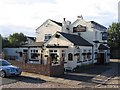
Site of the Junction Inn
Site of the recently demolished Junction Inn on Scott Gate off Guide Lane. As yet the roadside sign is still standing Image
2006: Image
2009: Image
Image: © Gerald England
Taken: 21 May 2012
0.07 miles
7
Guide Bridge Station Junction
Formerly Guide Bridge West Junction, the location has changed little in 25 years (see http://www.geograph.org.uk/photo/827960 ) apart from vegetation slowly enveloping the site.
Image: © Peter Whatley
Taken: 28 Sep 2013
0.08 miles
8
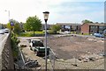
Loxley Homes
Image: © Gerald England
Taken: 15 Feb 2013
0.08 miles
10
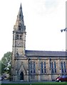
St. Stephen's Church, Audenshaw
This grade II listed building was built in 1846.
Image: © Peter Craine
Taken: 26 Sep 2006
0.09 miles