IMAGES TAKEN NEAR TO
Slate Lane, MANCHESTER, M34 5FS
Introduction
This page details the photographs taken nearby to Slate Lane, M34 5FS by members of the Geograph project.
The Geograph project started in 2005 with the aim of publishing, organising and preserving representative images for every square kilometre of Great Britain, Ireland and the Isle of Man.

There are currently over 7.5m images from over14,400 individuals and you can help contribute to the project by visiting https://www.geograph.org.uk
Image Map
Images are licensed for reuse under creativecommons.org/licenses/by-sa/2.0
Notes
- Clicking on the map will re-center to the selected point.
- The higher the marker number, the further away the image location is from the centre of the postcode.
Image Listing (134 Images Found)
Images are licensed for reuse under creativecommons.org/licenses/by-sa/2.0
Image
Details
Distance
1

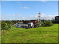
Ashton-under-Lyne fire station
Ashton-under-Lyne fire station, Slate Lane, off Ashton Moss Way, Audenshaw, Greater Manchester
Image: © Kevin Hale
Taken: 29 Jul 2010
0.01 miles
2

Ashton-under-Lyne fire station
Ashton-under-Lyne fire station, Slate Lane, off Ashton Moss Way, Audenshaw, Greater Manchester
Image: © Kevin Hale
Taken: 29 Jul 2010
0.01 miles
3
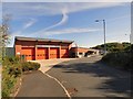
Community Fire Station, Ashton-under-Lyne
Actually stationed just inside Audenshaw on Slate Lane. This area used to be a three field small holding (named Woodbine Cottage) wedged between the two railway lines and Slate Lane.
Image: © John Topping
Taken: 17 Oct 2012
0.01 miles
5

Ashton under Lyne Community Fire Station
Image: © Gerald England
Taken: 30 Jun 2009
0.02 miles
6
Ashton Fire Station
Behind the old Slate Lane bridge is the new Ashton under Lyne Community Fire Station.
Image: © Gerald England
Taken: 30 Jun 2009
0.02 miles
7

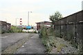
Railway line to Ashton Moss North Junction
The railway line from Denton Junction (SJ9196) to Ashton Moss North Junction (SJ9299), now wedged between the M60 (hidden by the trees) on the left and the fire station on the right.
Image: © John Topping
Taken: 17 Oct 2012
0.03 miles
8
Slate Lane Bridge
This part of Slate Lane was closed during the construction of the nearby M60 motorway. The bridge was declared unsafe for traffic. It crosses a long abandoned railway line which was a Northern loop from Guide Bridge.
Image: © Gerald England
Taken: 30 Jun 2009
0.04 miles
9
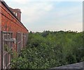
From Slate Lane Bridge
Somewhere underneath all the vegetation is the track of the long abandoned Northern spur line from Guide Bridge.
Image: © Gerald England
Taken: 30 Jun 2009
0.06 miles
10
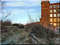
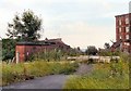
Disused Railway and Guide Bridge Mill
The course of the disused railway passes Guide Bridge Mill, a former cotton mill built in 1884.
Image: © David Dixon
Taken: 13 Dec 2012
0.06 miles