IMAGES TAKEN NEAR TO
Norwood Avenue, MANCHESTER, M29 7AP
Introduction
This page details the photographs taken nearby to Norwood Avenue, M29 7AP by members of the Geograph project.
The Geograph project started in 2005 with the aim of publishing, organising and preserving representative images for every square kilometre of Great Britain, Ireland and the Isle of Man.

There are currently over 7.5m images from over14,400 individuals and you can help contribute to the project by visiting https://www.geograph.org.uk
Image Map
Images are licensed for reuse under creativecommons.org/licenses/by-sa/2.0
Notes
- Clicking on the map will re-center to the selected point.
- The higher the marker number, the further away the image location is from the centre of the postcode.
Image Listing (9 Images Found)
Images are licensed for reuse under creativecommons.org/licenses/by-sa/2.0
Image
Details
Distance
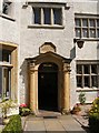
4
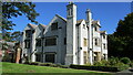
Dam House
A much altered hall with 1650 datestone but still with the long gallery on the top floor running east to west
Image: © Kevin Waterhouse
Taken: 21 Sep 2019
0.22 miles
5
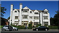
Dam House
The south front of the hall (1650 datestone) much altered and latterly used by the NHS. Now in the hands of a heritage trust (MAHT)
Image: © Kevin Waterhouse
Taken: 21 Sep 2019
0.23 miles
7
Dam House, Astley
Erected by the Mort family, 1650.
Image: © Julian Graham
Taken: 24 Sep 2005
0.23 miles
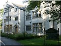
8
Dam House
Plaque reads Erected by Adam Mort and Margaret Mort 1650. This listed building has been saved by the local community and its present uses include tearooms and heritage centre.
Image: © SMJ
Taken: 29 Jul 2008
0.24 miles