IMAGES TAKEN NEAR TO
Stoneclough Rise, MANCHESTER, M26 1QU
Introduction
This page details the photographs taken nearby to Stoneclough Rise, M26 1QU by members of the Geograph project.
The Geograph project started in 2005 with the aim of publishing, organising and preserving representative images for every square kilometre of Great Britain, Ireland and the Isle of Man.

There are currently over 7.5m images from over14,400 individuals and you can help contribute to the project by visiting https://www.geograph.org.uk
Image Map
Images are licensed for reuse under creativecommons.org/licenses/by-sa/2.0
Notes
- Clicking on the map will re-center to the selected point.
- The higher the marker number, the further away the image location is from the centre of the postcode.
Image Listing (71 Images Found)
Images are licensed for reuse under creativecommons.org/licenses/by-sa/2.0
Image
Details
Distance
1
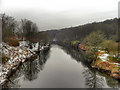
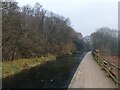
River Irwell, Ringley
Looking upstream from Ringley Bridge.
Image: © David Dixon
Taken: 11 Feb 2012
0.03 miles
2
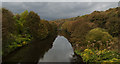
The River Irwell from Kearsley Road bridge
Image: © Ian Greig
Taken: 27 Oct 2016
0.05 miles
3
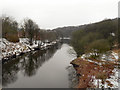
River Irwell
Looking upstream from Ringley Bridge
Image: © David Dixon
Taken: 11 Feb 2012
0.06 miles
4
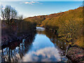
River Irwell, Ringley/Prestolee
View upstream from the bridge at Ringley Road.
Image: © David Dixon
Taken: 27 Feb 2021
0.07 miles
5
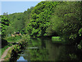
Kearsley - canal west of Ringley Bridge
This is a part of the Manchester, Bolton & Bury Canal which is in water.
Image: © Dave Bevis
Taken: 21 May 2012
0.07 miles
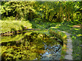
7
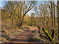
Footpath at Ringley
The path here runs to the right of what used to be the Manchester, Bolton and Bury Canal; now filled in, overgrown and consumed by the woodland.
Image: © David Dixon
Taken: 26 May 2012
0.08 miles
8
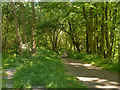
Path to Ringley
The Manchester arm of the canal is not in water after leaving Prestolee. This path leads from the canal towpath to Ringley Road. The remnants of the canal are on the left whilst the River Irwell is below, on the right.
Image: © David Dixon
Taken: 27 Feb 2021
0.08 miles
9
Manchester, Bolton and Bury Canal Approaching Ringley
This is presumably where the two Ringley Locks once stood. The canal is infilled to the east of this point.
Image: © David Dixon
Taken: 26 May 2012
0.08 miles
10
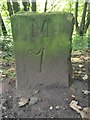
Old milemarker by the Manchester, Bolton & Bury Canal, Ringley
Milemarker by the Manchester, Bolton & Bury Canal, in parish of Kearsley (Bolton District), Ringley Locks (disused), Northwest of Kearsley Road.
Inscription reads:-
M
7
(To Manchester)
Grade II listed.
List Entry Number: 1067297 https://historicengland.org.uk/listing/the-list/list-entry/1067297
Surveyed
Milestone Society National ID: MBB-07
Image: © Milestone Society
Taken: Unknown
0.08 miles