IMAGES TAKEN NEAR TO
Sheepfoot Lane, MANCHESTER, M25 0DL
Introduction
This page details the photographs taken nearby to Sheepfoot Lane, M25 0DL by members of the Geograph project.
The Geograph project started in 2005 with the aim of publishing, organising and preserving representative images for every square kilometre of Great Britain, Ireland and the Isle of Man.

There are currently over 7.5m images from over14,400 individuals and you can help contribute to the project by visiting https://www.geograph.org.uk
Image Map
Images are licensed for reuse under creativecommons.org/licenses/by-sa/2.0
Notes
- Clicking on the map will re-center to the selected point.
- The higher the marker number, the further away the image location is from the centre of the postcode.
Image Listing (113 Images Found)
Images are licensed for reuse under creativecommons.org/licenses/by-sa/2.0
Image
Details
Distance
1
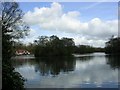
Heaton Park, Manchester
This park is one of the largest municipal parks in Europe and occupies 25% of the green space in Manchester. The photograph shows the boating lake and was taken from SD 830 036
Image: © Keith Williamson
Taken: 12 Apr 2005
0.08 miles
2

Manchester from the air
The boating lake at Heaton park is in the foreground, with the A576 Middleton Road to its left heading towards the city centre.
Viewed from a Manchester bound flight from Prague.
Image: © Thomas Nugent
Taken: 18 Apr 2014
0.08 miles
3
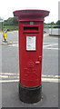
George V postbox on Meade Hill Road
Postbox No. M25 590.
See Image] for context.
Image: © JThomas
Taken: 10 Sep 2018
0.10 miles
4
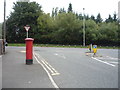
Meade Hill Road - junction with Sheepfoot Lane
Showing position of Postbox No. M25 590.
See Image] for postbox.
Image: © JThomas
Taken: 10 Sep 2018
0.10 miles
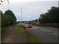
5
Meade Hill Road in Heaton Park, Manchester
Looking north-westward.
Image: © Peter Wood
Taken: 29 Oct 2017
0.10 miles

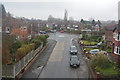
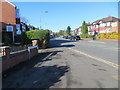
7
Sheepfoot Lane
On the right is the beginning of the railway tunnel under Heaton Park now used by Metrolink. The junction beyond is with Meade Hill Road. Heaton Park occupies the whole left side of the road.
Image: © Bill Boaden
Taken: 14 Jul 2010
0.11 miles
8
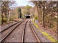
Approaching Heaton Park Tunnel
The southern approach to the tunnel under Heaton Park.
The Heaton Park Tunnel was constructed during the 19th century when the Lancashire and Yorkshire Railway’s line between Manchester and Radcliffe was being laid. Lord Wilton, the owner of the estate at that time, was not prepared to see his estate disfigured by a railway and insisted on the trains going under his estate and not in a cutting.
Although known as Heaton Park Tunnel it should, perhaps, be more correctly described as a covered way as it was not constructed by tunnelling but was dug out and then roofed over. It is possibly the shallowest railway tunnel in the UK. At one point, the top of the brick arch is less than two feet underground.
The 713-yards tunnel and a railway station (now Heaton Park Metrolink station) adjacent to the park’s Whittaker Lane/Bury Old Road entrance were opened in 1879.
Image: © David Dixon
Taken: 8 Apr 2014
0.12 miles