IMAGES TAKEN NEAR TO
Limley Grove, MANCHESTER, M21 8UB
Introduction
This page details the photographs taken nearby to Limley Grove, M21 8UB by members of the Geograph project.
The Geograph project started in 2005 with the aim of publishing, organising and preserving representative images for every square kilometre of Great Britain, Ireland and the Isle of Man.

There are currently over 7.5m images from over14,400 individuals and you can help contribute to the project by visiting https://www.geograph.org.uk
Image Map
Images are licensed for reuse under creativecommons.org/licenses/by-sa/2.0
Notes
- Clicking on the map will re-center to the selected point.
- The higher the marker number, the further away the image location is from the centre of the postcode.
Image Listing (131 Images Found)
Images are licensed for reuse under creativecommons.org/licenses/by-sa/2.0
Image
Details
Distance
1
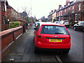
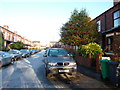
Pavement parking on Sandy Lane, Chorlton
Image: © Phil Champion
Taken: 17 Mar 2012
0.04 miles
2
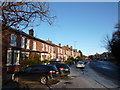
Nell Lane, Chorlton-cum-Hardy
Looking up the slight hill towards the junction with St Weburgh's Road and Sandy Lane. Behind the photographer's position Nell Lane crosses Houghend Bridge, by the corner of Chorlton Park.
Image: © Phil Champion
Taken: 18 Dec 2011
0.05 miles
3
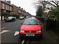
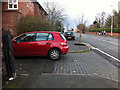
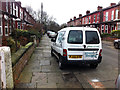
Parked on the pavement - Sandy Lane Chorlton
The thoughtless driver of this Volkswagen has parked his or her car more than halfway across the footway, alongside a street cabinet, which already narrows the pavement. Most of the other cars in the shot also have two wheels on the footway, though none have left so little room for pedestrians.
Highway Code rule 244:
"You MUST NOT park partially or wholly on the pavement in London, and should not do so elsewhere unless signs permit it. Parking on the pavement can obstruct and seriously inconvenience pedestrians, people in wheelchairs or with visual impairments and people with prams or pushchairs".
Image: © Phil Champion
Taken: 27 Feb 2012
0.05 miles
4
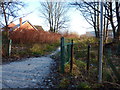
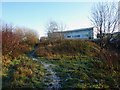
Footpath off Nell Lane
From Nell Lane a path follows Chorlton Brook along 'the Clough' towards Mauldeth Road West. The buildings of Chorlton High School, on the other side of the brook, can just be made out in the distance.
Image: © Phil Champion
Taken: 18 Dec 2011
0.06 miles
5
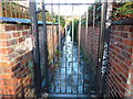
A gated alley, Chorlton-cum-Hardy
Between the rear of houses on Brookfield Avenue (on the left) and Beechwood Avenue (on the right). This back passage, like many others in the area, is subject to a Gating Order which prevents the public using the right of way. Gating orders are supposed to only be applied where there is persistant crime or anti-social behaviour related to the existence of the right of way. Usually the order is enforced by the erection of a large, un-climable security gate.
Image: © Phil Champion
Taken: 18 Dec 2011
0.06 miles
6
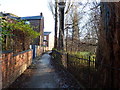
Footpath towards Nell Lane, Chorlton-cum-Hardy
This path runs eastwards from Barlow Moor Road, with a block of terraced streets to the north. Chorlton Park is to the right of the railings.
Image: © Phil Champion
Taken: 18 Dec 2011
0.06 miles
7
St Werburgh's Road, Chorlton
Looking north in the direction of the tram stop. The building on the left is converted barn at Park Brow Farm.
Image: © Phil Champion
Taken: 17 Mar 2012
0.07 miles
8
Footpath through the Clough, Chorlton-cum-Hardy
The buildings are at Chorlton High School, on the opposite side of Chorlton Brook. The path leads from Nell Lane to Mauldeth Road West at Twenty-seven steps.
Image: © Phil Champion
Taken: 18 Dec 2011
0.07 miles
9
Brookfield Avenue
Looking north from the end of this cul-de-sac of terraced houses. A light dusting of snow and an overnight frost made the surfaces a little bit slippy.
Image: © Phil Champion
Taken: 18 Dec 2011
0.07 miles
10
Brookfield Avenue, Chorlton
The width of this cul-de-sac, and the numbers of cars owned by the occupants is such, that most drivers here park with two wheels on the kerb. The driver of this van has parked it a little further onto the pavement than most.
Image: © Phil Champion
Taken: 27 Feb 2012
0.07 miles