IMAGES TAKEN NEAR TO
Egerton Road South, MANCHESTER, M21 0YN
Introduction
This page details the photographs taken nearby to Egerton Road South, M21 0YN by members of the Geograph project.
The Geograph project started in 2005 with the aim of publishing, organising and preserving representative images for every square kilometre of Great Britain, Ireland and the Isle of Man.

There are currently over 7.5m images from over14,400 individuals and you can help contribute to the project by visiting https://www.geograph.org.uk
Image Map
Images are licensed for reuse under creativecommons.org/licenses/by-sa/2.0
Notes
- Clicking on the map will re-center to the selected point.
- The higher the marker number, the further away the image location is from the centre of the postcode.
Image Listing (86 Images Found)
Images are licensed for reuse under creativecommons.org/licenses/by-sa/2.0
Image
Details
Distance
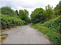
1
Fallowfield Loop
The start of the Fallowfield Loop at St Werbergh's Road.
Image: © Gerald England
Taken: 1 Jun 2013
0.11 miles
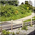
2
The Fallowfield Loop
Passing St Werburgh's Road tram stop.
Image: © Gerald England
Taken: 13 May 2017
0.12 miles
3
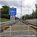
Tramway - Look Both Ways
Looking down the tramlines out of St Werburgh's Road tram stop.
Image: © Gerald England
Taken: 13 May 2017
0.14 miles
4
Disused railway line south east of Chorlton Junction
This was the trackbed of the former Midland Railway's Manchester South District Line from Manchester Central towards Tiviot Dale. The section from Chorlton Junction closed in the 1960s.
Since this photo was taken the section of line seen here has been re-opened as part of the Metrolink tram network. Phase 3a of the expansion plans included development of the South Manchester line as far as the new St Werburgh's Road station. The photographer's location is roughly in the vicinity of where the ramp from the island platform now stands, at the east end of the station. Tracks have been laid almost to the bridge carrying Mauldeth Road West over the line, with a head-shunt and points to allow trams to change tracks.
As part of Phase 3b, work is ongoing to extend the line towards Didsbury, with a another extension towards Manchester Airport, the junction being near Mauldeth Road West.
Image: © Phil Champion
Taken: 29 Aug 2009
0.14 miles
5
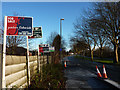
Mauldeth Road West, Hough End
Looking east from the bridge over the disused railway line (shortly to be re-opened as part of the Manchester Metrolink network). The For Sale / To Let signs relate to properties (probably apartments) on Chelsfield Grove. Chelsfield Grove was originally a short cul-de-sac of interwar semi-detached and detached houses, with Broughton Park Rugby Club at the end. When the rugby club relocated in the 1990s, the site was developed for housing and the road extended.
Image: © Phil Champion
Taken: 18 Dec 2011
0.14 miles
6
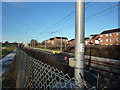
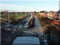
End of the line - for now
The new Metrolink route to Chorlton / St Werburgh's Road opened in 2011. Track had been laid for a short distance beyond the St Werburgh's Road stop, and was in use as a headshunt. Work was well underway on the next two extensions to the network - a continuation of the South Manchester Line along the disused railway to Didsbury, and a line to Manchester Airport. The latter will leave the existing line near this point, cutting across former school playing fields and Chorlton Brook to join Mauldeth Road West.
Image: © Phil Champion
Taken: 18 Dec 2011
0.14 miles
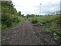
7

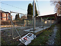
Warning notice on Metrolink line fencing
This is just beyond the temporary end of the line after the St Werburgh's Road tram stop. The line will be extended across this view, along the disused railway line to East Didsbury.
Image: © Phil Champion
Taken: 18 Dec 2011
0.14 miles
8
End of the line - for now
The new Metrolink route to Chorlton / St Werburgh's Road opened in 2011. Track had been laid for a short distance beyond the St Werburgh's Road stop, and was in use as a headshunt. Work was well underway on the next two extensions to the network - a continuation of the South Manchester Line along the disused railway to Didsbury, and a line to Manchester Airport. The latter will leave the existing line just north of this point.
The photographers position is at the foot of Twenty-seven Steps - a flight of steps (not actually 27 of them) leading up to Mauldeth Road West adjacent to the railway bridge.
Image: © Phil Champion
Taken: 18 Dec 2011
0.14 miles
9
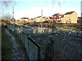
Metrolink fencing and equipment near Mauldeth Road West
The new tram route to Chorlton / St Werburgh's Road opened in 2011, with tracks being laid a short distance beyond the St Werburgh's Road stop. Work was well underway on the next two extensions to the network - a continuation of the South Manchester Line along the disused railway to East Didsbury (along the trackbed seen here), and a line to Manchester Airport which will leave the existing line just behind the photographer's position.
Image: © Phil Champion
Taken: 18 Dec 2011
0.14 miles
10
Current end of the Metrolink line near Mauldeth Road West
The disused railway line to Chorlton was re-opened as far as the new St Werburgh's Road stop in July 2011. The tracks were extended a short distance beyond the station. Work was well underway extending the route SE along the former heavy rail line to Didsbury. The line to Manchester Airport will leave the South Manchester Line just north of this point, to run across the triangular area of grass (already fenced off from the adjoining playing field), crossing Chorlton Brook, and joining Mauldeth Road West near Chorlton High School.
Image: © Phil Champion
Taken: 18 Dec 2011
0.14 miles