IMAGES TAKEN NEAR TO
St. Werburghs Road, MANCHESTER, M21 0UL
Introduction
This page details the photographs taken nearby to St. Werburghs Road, M21 0UL by members of the Geograph project.
The Geograph project started in 2005 with the aim of publishing, organising and preserving representative images for every square kilometre of Great Britain, Ireland and the Isle of Man.

There are currently over 7.5m images from over14,400 individuals and you can help contribute to the project by visiting https://www.geograph.org.uk
Image Map
Images are licensed for reuse under creativecommons.org/licenses/by-sa/2.0
Notes
- Clicking on the map will re-center to the selected point.
- The higher the marker number, the further away the image location is from the centre of the postcode.
Image Listing (96 Images Found)
Images are licensed for reuse under creativecommons.org/licenses/by-sa/2.0
Image
Details
Distance
2
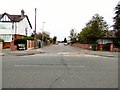
Egerton Road South, Chorlton-cum-Hardy
A residential road which crosses St. Werburgh's Road.
Image: © P L Chadwick
Taken: 7 May 2011
0.07 miles
3
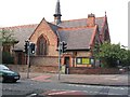
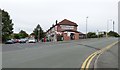
St Werburghs
This is St Werburghs Church on the corner of Wilbraham Road and St Werburghs Road. The picture was taken from SJ823940 looking north.
Image: © Dave Smethurst
Taken: 5 Sep 2005
0.09 miles
4
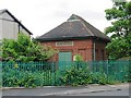
Electricity substation, corner of Egerton Road South & St. Werburgh's Road, Chorlton-cum-Hardy
Tucked away behind a lot of greenery is this electricity substation.
Image: © L S Wilson
Taken: 7 May 2011
0.10 miles
5
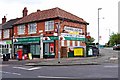
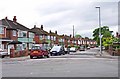
Egerton Road South Post Office, 127 Egerton Road South, Chorlton-cum-Hardy, Manchester
A corner shop in every sense, being on the corner of Egerton Road South, and St. Werburgh's Road. As well as being a post office, it is also a grocers and newsagents.
Another view:- Image
Image: © P L Chadwick
Taken: 7 May 2011
0.11 miles
6
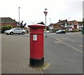
Anonymous postbox (M21 653)
The postbox outside Egerton Road PO Image on the corner of St Werburgh's Road carries no regal cipher.
Image: © Gerald England
Taken: 1 Oct 2016
0.11 miles
7
Egerton Road South Post Office
On the corner of St Werburgh's Road. Under the bridge on the right is St Werburgh's Road Metrolink tram stop. In front of the post office is postbox with no regal cipher Image
Image: © Gerald England
Taken: 1 Oct 2016
0.11 miles
8
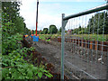
Piling along Metrolink extension route
Clearance of the route for the Metrolink extension to St Werburgh's Road was well under way. The tram route utilises the formerly disused Manchester South District Line. This is the section between Wilbraham Road and St Werburgh’s Road.
Image: © Phil Champion
Taken: 29 Aug 2009
0.11 miles
9
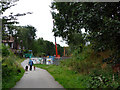
End of the Fallowfield Loop Cycleway
The disused Fallowfield Loop railway line and a short section of the South District Line west of St Werburgh's Road (seen here) were converted into a cycle path in the 1990. This was the final section linking to the end of Sidbury Road. By summer 2009 work was well under way to re-open the line from Old Trafford to Chorlton Junction as an extension to the Metrolink tram network. The cranes visible in the photo were being used by a piling contractor. The line re-opened on the 7th July 2011. The cycle path has been realigned to cross the track via a level crossing and run along the north side as far as the new St Werburgh's Road stop.
Image: © Phil Champion
Taken: 29 Aug 2009
0.11 miles
10
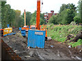
Piling contractors equipment, Metrolink extension to St Werburgh's Road
The disused railway line through Chorlton has been re-utilised for an extension to the Metrolink tram network. By December 2009 work was well under way. This was the section between the site of Chorlton-cum-Hardy station and St Werburgh's Road.
Image: © Phil Champion
Taken: 29 Aug 2009
0.11 miles