IMAGES TAKEN NEAR TO
Adscombe Street, MANCHESTER, M16 7AQ
Introduction
This page details the photographs taken nearby to Adscombe Street, M16 7AQ by members of the Geograph project.
The Geograph project started in 2005 with the aim of publishing, organising and preserving representative images for every square kilometre of Great Britain, Ireland and the Isle of Man.

There are currently over 7.5m images from over14,400 individuals and you can help contribute to the project by visiting https://www.geograph.org.uk
Image Map
Images are licensed for reuse under creativecommons.org/licenses/by-sa/2.0
Notes
- Clicking on the map will re-center to the selected point.
- The higher the marker number, the further away the image location is from the centre of the postcode.
Image Listing (29 Images Found)
Images are licensed for reuse under creativecommons.org/licenses/by-sa/2.0
Image
Details
Distance
1
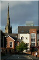
Whitnail Street in Moss Side, Manchester
Whitnail Street looking towards flats on Raby Street in Moss Side, Manchester. St Mary's Church, Hulme and the Beetham Tower on Deansgate are in the background.
Image: © Stephen Taylor
Taken: 3 Oct 2010
0.13 miles
2
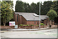
Manchester Chinese Christian Church
Yarburgh Street.
Image: © David Dixon
Taken: 13 Jul 2010
0.15 miles
3
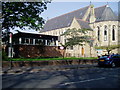
St Edmund's Church Whalley Range, Manchester
St Edmund's Church Whalley Range was a large stone Victorian church. The congregation now worship in the brick built church hall. The old church has now been converted into flats.
Image: © R Greenhalgh
Taken: 15 Apr 2007
0.17 miles
4
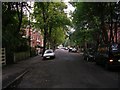
Range Road
Looking down Range Road, Whalley Range from its junction with Alexandra Road South. SJ83359537.
Image: © Keith Williamson
Taken: 28 Sep 2005
0.17 miles
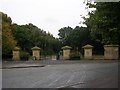
5
Alexandra Park
The northern entrance to Alexandra Park.
Image: © David Dixon
Taken: 13 Jul 2010
0.17 miles
6
Alexandra Park, Whalley Range
Entrance to Alexandra Park by the junction of Alexandra Road and Claremont Road. SJ83349536.
Image: © Keith Williamson
Taken: 28 Sep 2005
0.17 miles
7
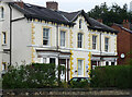
12-14 Withington Road, Manchester
One of three surviving pairs of early Victorian villas from a development by the banker Samuel Brooks. He built up the area from the early 1830s and named it Whalley Range. Grade II listed.
Image: © Stephen Richards
Taken: 17 Aug 2016
0.17 miles
8
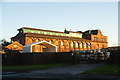
Hydes Brewery, Moss Side
There has been a brewery here since 1861, but the site is now up for sale as a development opportunity. The building is Grade II listed. Hydes will be moving to new premises in Salford.
Image: © Bill Boaden
Taken: 1 Dec 2012
0.17 miles
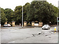
10
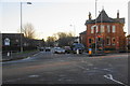
The Brooks Bar road junction
Ahead is Withington Road which leads to Chorlton. At this point Old Trafford, Whalley Range, Hulme and Moss Side all merge into each other.
Image: © Bill Boaden
Taken: 1 Dec 2012
0.19 miles