IMAGES TAKEN NEAR TO
Scotforth Close, MANCHESTER, M15 5AP
Introduction
This page details the photographs taken nearby to Scotforth Close, M15 5AP by members of the Geograph project.
The Geograph project started in 2005 with the aim of publishing, organising and preserving representative images for every square kilometre of Great Britain, Ireland and the Isle of Man.

There are currently over 7.5m images from over14,400 individuals and you can help contribute to the project by visiting https://www.geograph.org.uk
Image Map
Images are licensed for reuse under creativecommons.org/licenses/by-sa/2.0
Notes
- Clicking on the map will re-center to the selected point.
- The higher the marker number, the further away the image location is from the centre of the postcode.
Image Listing (70 Images Found)
Images are licensed for reuse under creativecommons.org/licenses/by-sa/2.0
Image
Details
Distance
1

Manchester : The A57(M)
The Mancunian Way is a two mile long motorway in Manchester, England. It is officially made up of the A57(M) and A635(M) motorways, although the latter does not appear on road signs for practical reasons.
Image: © Lewis Clarke
Taken: 11 Oct 2014
0.10 miles
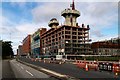
2
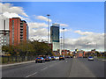
Chester Road (A56)
The A56 is one of the major routes into (and through) Manchester cuty centre. This photograph is taken from outside Image], near to the junction with the Mancunian Way (A57)
Ahead, the tall red-clad building is Image] and further on is the Hilton Hotel (Beetham Tower).
Image: © David Dixon
Taken: 16 Oct 2011
0.12 miles
3
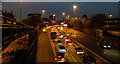
Mancunian Way
The A57(M), Mancunian Way, at rush hour.
Image: © Peter McDermott
Taken: 4 Dec 2014
0.13 miles
4
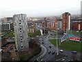
Roundabout From the Roof of Hulme Court
From roof of Hulme Court from roof of lift and plant room. It shows the roundabout with clockwise from 7 o'clock - Chorlton Road; Chester Road; Mancunian Way emerging from underpass and roundabout exit to Deansgate / Knott Mill.
Image: © Anthony Parkes
Taken: 18 Jan 2012
0.14 miles
5
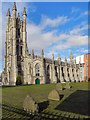
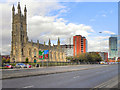
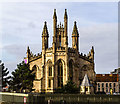
St George's Church
The Church of St George on Chester Road, near to the Mancunian Way junction, was a Commissioners' church, built between 1826 and 1828 and restored in 1884.
St George's closed as a place for religious worship in 1984. Designated a Grade II* listed building, this grand building was eventually converted for use as residential apartments in 2000-2.
More information at http://manchesterhistory.net/manchester/outside/stgeorge.html (Manchester History net)
Image: © David Dixon
Taken: 16 Oct 2011
0.14 miles
6
Chester Road
Development alongside Chester Road.
Image: © Peter McDermott
Taken: 21 Jul 2019
0.15 miles
7
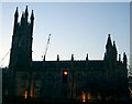
Church of St George, Chester Road, Hulme
St Georg'e Church, alongside the main A56, Chester Road, as it approaches Manchester city centre. Other landmarks in the photograph are Image] and the Hilton Hotel (Beetham Tower).
Image: © David Dixon
Taken: 16 Oct 2011
0.15 miles
8
Church Converted into Flats on A56/Mancunian Way Roundabout
Image: © Gary Barber
Taken: 18 Apr 2005
0.15 miles
9
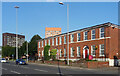
215-219 Chester Road, Manchester
A group of three early C19th houses. They are not listed which might be because beyond the facades little of the original fabric survives.
They were offices, known as St George's House, but have since fallen into disuse and been boarded up (2023).
Image: © Stephen Richards
Taken: 17 Aug 2016
0.15 miles
10
St George's Church
St George's Church which has been converted into flats.
Image: © Peter McDermott
Taken: 11 Mar 2018
0.15 miles