IMAGES TAKEN NEAR TO
Upton Street, MANCHESTER, M11 1PL
Introduction
This page details the photographs taken nearby to Upton Street, M11 1PL by members of the Geograph project.
The Geograph project started in 2005 with the aim of publishing, organising and preserving representative images for every square kilometre of Great Britain, Ireland and the Isle of Man.

There are currently over 7.5m images from over14,400 individuals and you can help contribute to the project by visiting https://www.geograph.org.uk
Image Map
Images are licensed for reuse under creativecommons.org/licenses/by-sa/2.0
Notes
- Clicking on the map will re-center to the selected point.
- The higher the marker number, the further away the image location is from the centre of the postcode.
Image Listing (81 Images Found)
Images are licensed for reuse under creativecommons.org/licenses/by-sa/2.0
Image
Details
Distance
1
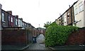
Alleyway
Alley leading off Sirdar Street. Back alleyways like this were a common sight in Manchester and other great northern industrial cities. In the middle of the last century, large clearances started and now there are only relatively small pockets of this type of housing left.
Image: © Stephen Burton
Taken: 23 May 2006
0.05 miles
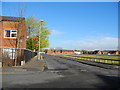
2
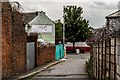
Copperas Lane
View looking down Copperas Lane.
Image: © Peter McDermott
Taken: 26 Jun 2017
0.06 miles
3
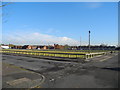
Empty Streets ? Higher Openshaw
Waiting for the redevelopment of the Toxteth Street area, from the 2005 East Manchester Redevelopment Plan!
Image: © John Topping
Taken: 5 Nov 2012
0.07 miles
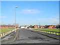
4
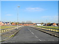
Bowness Street - Higher Openshaw
View north from Toxteth Street.
Image: © John Topping
Taken: 5 Nov 2012
0.07 miles
5
Silverdale Street - Higher Openshaw
View north from Toxteth Street.
Image: © John Topping
Taken: 5 Nov 2012
0.07 miles
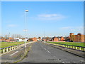
6
Gransmoor Road - Higher Openshaw
View north from Toxteth Street along Gransmoor Road.
Image: © John Topping
Taken: 5 Nov 2012
0.08 miles
7
Cheeryble Street - Higher Openshaw
View north from Toxteth Street.
Image: © John Topping
Taken: 5 Nov 2012
0.09 miles
8
Ashton Canal
Footbridge over the Ashton Canal.
Image: © Peter McDermott
Taken: 30 Nov 2014
0.09 miles
9
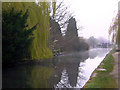
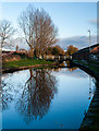
Ashton Canal
Early morning view of Ashton Canal looking towards Ashton. At this time of year with the Willow trees, just turning green and mist rising from the water even an urban canal can look beautiful.
Image: © Stephen Burton
Taken: 5 Apr 2007
0.09 miles
10
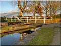
Clockhouse Swing Bridge, Fairfield
Bridge #15 on the Ashton Canal is this swing bridge at Fairfield. It takes the path from Copperas Lane, on the southern side of the canal, to the playing fields on the northern side.
Droylsden had two 'Clockhouses', so the workers could know when it was time to awake for their toil in the mills. The north clockhouse was on Greenside Lane overlooking the Medlock Valley. The south clockhouse was near here at Yew Tree Farm, close to the Moravian Settlement. Apparently (http://homepage.ntlworld.com/william.mcdonald7/droylsden.htm All About Droylsden) there were only five clockhouses in the whole of Britain and Droylsden had two of them. Sadly they were allowed to disappear before their importance was realised.
Image: © David Dixon
Taken: 15 Nov 2012
0.09 miles