IMAGES TAKEN NEAR TO
Ivinghoe Aston, LEIGHTON BUZZARD, LU7 9DJ
Introduction
This page details the photographs taken nearby to LU7 9DJ by members of the Geograph project.
The Geograph project started in 2005 with the aim of publishing, organising and preserving representative images for every square kilometre of Great Britain, Ireland and the Isle of Man.

There are currently over 7.5m images from over14,400 individuals and you can help contribute to the project by visiting https://www.geograph.org.uk
Image Map
Images are licensed for reuse under creativecommons.org/licenses/by-sa/2.0
Notes
- Clicking on the map will re-center to the selected point.
- The higher the marker number, the further away the image location is from the centre of the postcode.
Image Listing (12 Images Found)
Images are licensed for reuse under creativecommons.org/licenses/by-sa/2.0
Image
Details
Distance
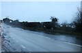
1
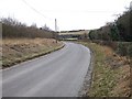
Lane from Ivinghoe Aston
Taken from just outside the gated entrance to a quarry looking southeastwards along the lane which links Ivinghoe Aston with the B489.
Image: © Rob Farrow
Taken: 22 Feb 2009
0.05 miles
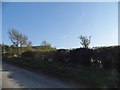
3
Old chalk quarry
Near Ivinghoe Aston. It now looks as if it has been filled in and become an ATV/bike circuit - it is not apparent on Google Earth imagery of 2006.
Image: © M J Richardson
Taken: 11 Jul 2013
0.12 miles
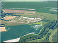
4
Chalk quarry at Ivinghoe Aston
Looking north from the slopes of Ivinghoe Beacon.
Image: © Simon Mortimer
Taken: 24 Mar 2006
0.13 miles
5
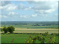
View north from Icknield Way
The ancient route is now the B489 here. The viewpoint is below Ivinghoe Beacon.
Image: © Robin Webster
Taken: 25 May 2014
0.15 miles
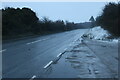
7
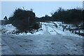
An icy fate
The track to Gallows Hill is not safe for anything to use as the rain makes the icy surface even more dangerous.
Image: © David Howard
Taken: 18 Dec 2022
0.24 miles
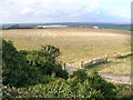
8
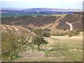
Coombe Bottom from the slopes of Ivinghoe Beacon
Looking north, with Edlesborough church visible in the background.
Image: © Simon Mortimer
Taken: 24 Mar 2006
0.24 miles
10
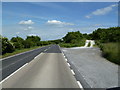
B489, near Ivinghoe
Just north of Ivinghoe Beacon.
Image: © Mr Biz
Taken: 29 Jun 2013
0.25 miles