IMAGES TAKEN NEAR TO
LU7 7YD
Introduction
This page details the photographs taken nearby to LU7 7YD by members of the Geograph project.
The Geograph project started in 2005 with the aim of publishing, organising and preserving representative images for every square kilometre of Great Britain, Ireland and the Isle of Man.

There are currently over 7.5m images from over14,400 individuals and you can help contribute to the project by visiting https://www.geograph.org.uk
Image Map
Images are licensed for reuse under creativecommons.org/licenses/by-sa/2.0
Notes
- Clicking on the map will re-center to the selected point.
- The higher the marker number, the further away the image location is from the centre of the postcode.
Image Listing (5 Images Found)
Images are licensed for reuse under creativecommons.org/licenses/by-sa/2.0
Image
Details
Distance
1
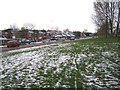
Linslade: Bideford Green
Part of the large 1970s housing development on the western side of Linslade, viewed from the grassy embankment up to Soulbury Road, with a light dusting of snow on the ground. The road naming committee were obviously uninspired as every small cul-de-sac on the estate is on Bideford Green, and the house numbers run to 450 and beyond.
Image: © Nigel Cox
Taken: 28 Dec 2005
0.18 miles
2
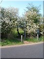
Public Footpath
A footpath that starts on the edge of Linslade, heading towards 'The Lodge' on the Liscombe Park estate.
Image: © Mr Biz
Taken: 15 Apr 2007
0.20 miles
4
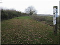
The footpath to Hop Gardens
Off Derwent Road the footpath to Hop Gardens
Image: © Shaun Ferguson
Taken: 12 Nov 2011
0.24 miles
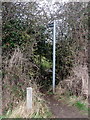
5
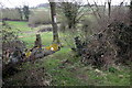
Footpath marker and warnings in the hedge
Image: © Philip Jeffrey
Taken: 15 Apr 2013
0.24 miles