IMAGES TAKEN NEAR TO
Dove Tree Road, LEIGHTON BUZZARD, LU7 3UP
Introduction
This page details the photographs taken nearby to Dove Tree Road, LU7 3UP by members of the Geograph project.
The Geograph project started in 2005 with the aim of publishing, organising and preserving representative images for every square kilometre of Great Britain, Ireland and the Isle of Man.

There are currently over 7.5m images from over14,400 individuals and you can help contribute to the project by visiting https://www.geograph.org.uk
Image Map
Images are licensed for reuse under creativecommons.org/licenses/by-sa/2.0
Notes
- Clicking on the map will re-center to the selected point.
- The higher the marker number, the further away the image location is from the centre of the postcode.
Image Listing (17 Images Found)
Images are licensed for reuse under creativecommons.org/licenses/by-sa/2.0
Image
Details
Distance
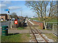
1
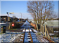
Leighton Buzzard: Narrow gauge railway
The railway was originally built in 1919 to carry sand from nearby quarries to the now dismantled Leighton Buzzard to Dunstable standard gauge railway line close to Page's Park. It closed as an industrial line in 1969, but was taken over by volunteers to be run as a heritage railway. The railway has a very informative website here http://www.buzzrail.co.uk/ A light dusting of snow covers the ground in this view, taken looking north westwards where the railway runs parallel to the road called Meadway on the left. The brick walls are the parapets of the railway bridge over Clipstone Brook, a tributary of the River Ouzel.
Image: © Nigel Cox
Taken: 28 Dec 2005
0.07 miles
2
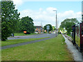
Road and railway, Leighton Buzzard
The Leighton Buzzard Light Railway runs beside Meadway up a long straight on the outskirts of town.
Image: © Robin Webster
Taken: 25 May 2014
0.09 miles
4
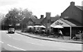
The Clay Pipe public house, Leighton Buzzard
From the Leighton Buzzard Light Railway. The name reflects Leighton Buzzard's role in the extraction of clay and sand. A trade that still continues and there is a clay tile works adjoining one end of the light railway.
Image: © Chris Allen
Taken: 30 Sep 2017
0.15 miles
5

The Clay Pipe, Appenine Way, Leighton Buzzard
Seen from a passing Leighton Buzzard railway train.
Image: © Robert Eva
Taken: 17 Jun 2018
0.15 miles
7
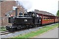
Leighton Buzzard Railway train at Meadway
Baldwin 4-6-0PT No. 778 runs alongside Meadway opposite the Clay Pipe pub. This is the first train of the day, the 10.30 from Pages Park to the new destination of Munday's Hill.
Image: © Bob Walters
Taken: 1 May 2022
0.16 miles
8
Leighton Buzzard Railway in the suburbs
A train about to cross Appenine Way.
Image: © Robin Webster
Taken: 25 May 2014
0.17 miles
9
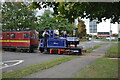
'Doll' crossing Apennine Way
Leighton Buzzard Railway 0-6-0T 'Doll' crossing Apennine Way with a train headed for Stonehenge during the LBR's Autumn Steam Gala. This crossing does not require the train to stop to deploy flagmen to control the road traffic as at most other crossings on the route. Much whistling occurs as the train approaches to warn road users.
Image: © Bob Walters
Taken: 30 Sep 2017
0.17 miles
10
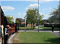
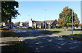
Crossing Appenine Way
Unlike most heritage lines, the Leighton Buzzard Narrow Gauge Railway follows an urban route for much of its length. It goes between houses and factories, runs beside suburban streets and crosses several roads.
Image: © Des Blenkinsopp
Taken: 6 May 2013
0.18 miles