IMAGES TAKEN NEAR TO
Kemsley Drive, LEIGHTON BUZZARD, LU7 3HE
Introduction
This page details the photographs taken nearby to Kemsley Drive, LU7 3HE by members of the Geograph project.
The Geograph project started in 2005 with the aim of publishing, organising and preserving representative images for every square kilometre of Great Britain, Ireland and the Isle of Man.

There are currently over 7.5m images from over14,400 individuals and you can help contribute to the project by visiting https://www.geograph.org.uk
Image Map
Images are licensed for reuse under creativecommons.org/licenses/by-sa/2.0
Notes
- Clicking on the map will re-center to the selected point.
- The higher the marker number, the further away the image location is from the centre of the postcode.
Image Listing (5 Images Found)
Images are licensed for reuse under creativecommons.org/licenses/by-sa/2.0
Image
Details
Distance
1
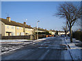
Leighton Buzzard: Churchill Road
Viewed looking eastwards with a light covering of snow on the ground.
Image: © Nigel Cox
Taken: 28 Dec 2005
0.21 miles
2
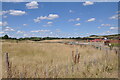
Chamberlain's Barn Quarry
Looking north west across the disused Chamberlain's Barn Quarry from the new housing development in Kemsley Drive. The old Leighton Buzzard sand quarries are being redeveloped for housing across a large area east of the town.
Image: © Bob Walters
Taken: 8 Aug 2022
0.23 miles
3
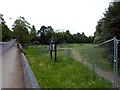
Adams Bottom, Heath Road, Leighton Buzzard
A small open space maintained by Leighton-Linslade Town Council. Has a play area and a Town Council noticeboard.
Image: © shirokazan
Taken: 26 May 2010
0.23 miles
4
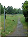
Adams Bottom Park, Leighton Buzzard
The beginning of a footpath that takes you onto the Greensand Ridge Walk, Two Ridges Link and the Grand Union Canal Walk.
Image: © Mr Biz
Taken: 30 May 2011
0.24 miles
5
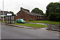
Bus stop and sheltered housing on Heath Road
Image: © Philip Jeffrey
Taken: 15 Jun 2013
0.24 miles