IMAGES TAKEN NEAR TO
Greenhill, LEIGHTON BUZZARD, LU7 3AE
Introduction
This page details the photographs taken nearby to Greenhill, LU7 3AE by members of the Geograph project.
The Geograph project started in 2005 with the aim of publishing, organising and preserving representative images for every square kilometre of Great Britain, Ireland and the Isle of Man.

There are currently over 7.5m images from over14,400 individuals and you can help contribute to the project by visiting https://www.geograph.org.uk
Image Map
Images are licensed for reuse under creativecommons.org/licenses/by-sa/2.0
Notes
- Clicking on the map will re-center to the selected point.
- The higher the marker number, the further away the image location is from the centre of the postcode.
Image Listing (8 Images Found)
Images are licensed for reuse under creativecommons.org/licenses/by-sa/2.0
Image
Details
Distance
1
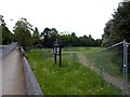
Adams Bottom, Heath Road, Leighton Buzzard
A small open space maintained by Leighton-Linslade Town Council. Has a play area and a Town Council noticeboard.
Image: © shirokazan
Taken: 26 May 2010
0.09 miles
2
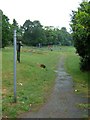
Adams Bottom Park, Leighton Buzzard
The beginning of a footpath that takes you onto the Greensand Ridge Walk, Two Ridges Link and the Grand Union Canal Walk.
Image: © Mr Biz
Taken: 30 May 2011
0.10 miles
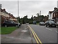
4
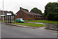
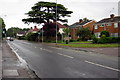
Bus stop and sheltered housing on Heath Road
Image: © Philip Jeffrey
Taken: 15 Jun 2013
0.11 miles
7
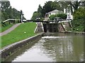
Below Leighton Lock
Lock 27 on the Grand Union Canal just north of Linslade.
Image: © M J Richardson
Taken: 6 Sep 2008
0.24 miles
8
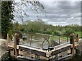
Leighton Lock
New gates installed in 2021. The new gates are handmade in traditional oak and cost around £50,000. The pair combined weigh an estimated total of nine tonnes.
Image: © Andrew Abbott
Taken: 20 May 2021
0.25 miles