IMAGES TAKEN NEAR TO
Kings Street, LEIGHTON BUZZARD, LU7 0YA
Introduction
This page details the photographs taken nearby to Kings Street, LU7 0YA by members of the Geograph project.
The Geograph project started in 2005 with the aim of publishing, organising and preserving representative images for every square kilometre of Great Britain, Ireland and the Isle of Man.

There are currently over 7.5m images from over14,400 individuals and you can help contribute to the project by visiting https://www.geograph.org.uk
Image Map
Images are licensed for reuse under creativecommons.org/licenses/by-sa/2.0
Notes
- Clicking on the map will re-center to the selected point.
- The higher the marker number, the further away the image location is from the centre of the postcode.
Image Listing (11 Images Found)
Images are licensed for reuse under creativecommons.org/licenses/by-sa/2.0
Image
Details
Distance
1
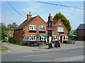
The Carpenters Arms, Stewkley
Found in Stewkley's "South End", the pub is located just opposite the Dunton Road junction.
Image: © Mr Biz
Taken: 22 May 2008
0.03 miles
3
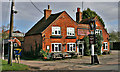
The Carpenter's Arms
This Public House is located in the part of Stewkely known as 'South End'
Image: © Richard Thomas
Taken: 28 Feb 2007
0.04 miles
4
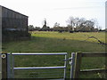
Footpath nearing Stewkley
Footpath from Ash Farm by Wing Road Farm nearing Stewkley
Image: © Shaun Ferguson
Taken: 12 Nov 2011
0.08 miles
5
Methodist Church in South End, Stewkley
Image: © Mat Fascione
Taken: 16 Aug 2015
0.13 miles
6
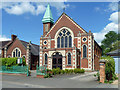
Stewkley Methodist Church
With a hall to the left.
Image: © Robin Webster
Taken: 25 May 2014
0.14 miles
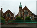
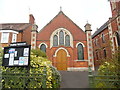
7
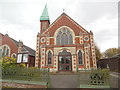
Stewkley Methodist Church (1)
Situated in High Street South LU7 0HU, this church dates from 1903 and is one of seventeen churches in the Vale of Aylesbury Methodist Circuit. Services are held here each Sunday at 10.30am with activities taking place during the week. The church hall can be seen to the left of the photo. The history of this church can be seen on the Stewkley website https://www.stewkley.org/churches/church-m.php refers.
Image: © David Hillas
Taken: 12 Apr 2019
0.14 miles
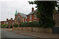
8
Stewkley Methodist Church (2)
Taken in High Street South, this photo shows the church hall with the church itself to the right of the photo. The Parish noticeboard can be seen to the left of the photo. Since September 2006, this church has been a member of the Vale of Aylesbury Methodist Circuit, although it had previously been in the Leighton Buzzard Circuit then the South Bedfordshire Circuit. Incidentally, a Circuit comprises of several Methodist Churches, following which a group of Circuits makes up a Methodist District. In the case of the Vale of Aylesbury Circuit, it is one of twenty three circuits that make up the Northampton District.
Image: © David Hillas
Taken: 12 Apr 2019
0.14 miles
9
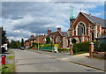
High Street South, Stewkley
Looking towards the Methodist Church
Image: © David Howard
Taken: 18 Jun 2023
0.15 miles