IMAGES TAKEN NEAR TO
Portland Road, LUTON, LU4 8AX
Introduction
This page details the photographs taken nearby to Portland Road, LU4 8AX by members of the Geograph project.
The Geograph project started in 2005 with the aim of publishing, organising and preserving representative images for every square kilometre of Great Britain, Ireland and the Isle of Man.

There are currently over 7.5m images from over14,400 individuals and you can help contribute to the project by visiting https://www.geograph.org.uk
Image Map
Images are licensed for reuse under creativecommons.org/licenses/by-sa/2.0
Notes
- Clicking on the map will re-center to the selected point.
- The higher the marker number, the further away the image location is from the centre of the postcode.
Image Listing (10 Images Found)
Images are licensed for reuse under creativecommons.org/licenses/by-sa/2.0
Image
Details
Distance
1
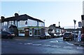
Beresford Road at the junction of Dunstable Road
Image: © David Howard
Taken: 6 Nov 2022
0.11 miles
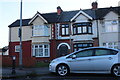
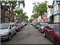
3
Stylish 1930s semi-detached houses, Dunstable Road, Luton
Image: © Robin Stott
Taken: 24 Feb 2017
0.13 miles


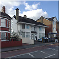
6
Former pub converted to a mosque, Kingsway, Luton
So a local man told me. Google Streetview shows that in 2009 this was the Kingsway Arms. In 2012 the conversion of the closed pub began. There is an extensive single-storey building on the north side, perhaps the former function room which (speculating) is now the place of worship. The part shown in the photograph may be the community centre. The view is across Connaught Road.
Image: © Robin Stott
Taken: 24 Feb 2017
0.17 miles
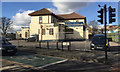
7
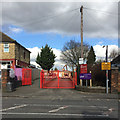
Dunstable Road entrance to Maidenhall Primary School, west Luton
I was a pupil here briefly in the early 1950s. Schools didn't have slogans then; now it's 'Believe Achieve Inspire'.
Image: © Robin Stott
Taken: 24 Feb 2017
0.18 miles
8
Luton: Conway Road
Looking towards Dunstable Road.
Image: © Nigel Cox
Taken: 25 Jun 2006
0.20 miles
9

Demolition at Maidenhall Primary School off Dunstable Road, west Luton
Works for the Projects Design and Delivery Team of Luton Borough Council were being carried out by Gray and Sons Builders Ltd. I was a pupil here briefly in the early 1950s. The 'Maiden' element of the name may recall Maiden Common Farm, shown nearby on late 19th-century maps.
Image: © Robin Stott
Taken: 24 Feb 2017
0.21 miles
10
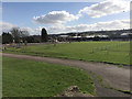
Kingsway Recreation Ground, west Luton
I remember as a child, in the late 1940s perhaps, seeing football being played on the Rec. Photographed from near the Dunstable Road entrance. Winsdon Hill on the skyline.
Image: © Robin Stott
Taken: 24 Feb 2017
0.24 miles