IMAGES TAKEN NEAR TO
Dovehouse Hill, LUTON, LU2 9ES
Introduction
This page details the photographs taken nearby to Dovehouse Hill, LU2 9ES by members of the Geograph project.
The Geograph project started in 2005 with the aim of publishing, organising and preserving representative images for every square kilometre of Great Britain, Ireland and the Isle of Man.

There are currently over 7.5m images from over14,400 individuals and you can help contribute to the project by visiting https://www.geograph.org.uk
Image Map
Images are licensed for reuse under creativecommons.org/licenses/by-sa/2.0
Notes
- Clicking on the map will re-center to the selected point.
- The higher the marker number, the further away the image location is from the centre of the postcode.
Image Listing (17 Images Found)
Images are licensed for reuse under creativecommons.org/licenses/by-sa/2.0
Image
Details
Distance
2
Park on Hartsfield Road, Luton
This runs between here and Vauxhall Way to the end of Hartsfield Road.
Image: © David Howard
Taken: 12 Feb 2023
0.08 miles
3
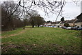
Autumn Colours
Autumn colours in Luton's Dovehouse Hill.
Image: © Mary and Angus Hogg
Taken: 30 Sep 2008
0.10 miles
4

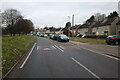
Crawley Green Road
Looking up the hill from Falconers Road.
Image: © Thomas Nugent
Taken: 22 Jun 2009
0.11 miles
5
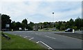
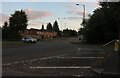
Roundabout at Vauxhall Way
At the junction of Crawley Green Road.
Image: © Thomas Nugent
Taken: 22 Jun 2009
0.13 miles
6
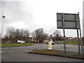
Roundabout on Vauxhall Way, Luton
Looking along Crawley Green Road
Image: © David Howard
Taken: 11 Jul 2020
0.13 miles
8
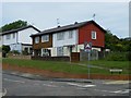
Williton Road
A BISF (Bristsh Iron & Steel Federation) house at the junction of Crawley Green Road.
Follow this http://www.foursteelwalls.co.uk/casestudies/cs-bisf.html for more information about BISF houses.
Image: © Thomas Nugent
Taken: 22 Jun 2009
0.14 miles
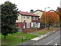
9
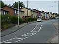
Ashcroft Road
BISF (British Iron & Steel Federation) houses such as these are common in this area.
Follow this http://www.foursteelwalls.co.uk/casestudies/cs-bisf.html for more information about BISF houses.
Image: © Thomas Nugent
Taken: 22 Jun 2009
0.16 miles
10
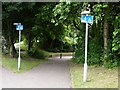
Steep path leading to underpass
The signs say it all! The underpass is at the Vauxhall Way/Crawley Green Road roundabout.
Image: © Thomas Nugent
Taken: 22 Jun 2009
0.17 miles