IMAGES TAKEN NEAR TO
Windmill Road, LUTON, LU1 3XW
Introduction
This page details the photographs taken nearby to Windmill Road, LU1 3XW by members of the Geograph project.
The Geograph project started in 2005 with the aim of publishing, organising and preserving representative images for every square kilometre of Great Britain, Ireland and the Isle of Man.

There are currently over 7.5m images from over14,400 individuals and you can help contribute to the project by visiting https://www.geograph.org.uk
Image Map
Images are licensed for reuse under creativecommons.org/licenses/by-sa/2.0
Notes
- Clicking on the map will re-center to the selected point.
- The higher the marker number, the further away the image location is from the centre of the postcode.
Image Listing (101 Images Found)
Images are licensed for reuse under creativecommons.org/licenses/by-sa/2.0
Image
Details
Distance
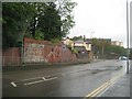
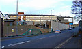
1

Kimpton Road
A railway bridge once crossed the road here. The line (out of sight on the left) has been recently excavated in preparation for the creation of a guided busway.
Image: © Thomas Nugent
Taken: 18 Nov 2011
0.01 miles
2
Luton: Former Gallows Road railway bridge
This is the site of the former Great Northern Railway's Luton to Hertford line bridge over the former Gallows Road, now the A505 Kimpton Road. Having been opened around 1860 the line was finally closed to passenger traffic in 1965. This is the southern bridge abutment but the one on the other side of the road has been demolished. See Image
The road is shown as Gallows Road on large scale Ordnance Survey mapping up to 1901, but by 1924 the mapping was showing that it had acquired its current moniker.
Image: © Nigel Cox
Taken: 26 Aug 2011
0.01 miles
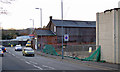
3
Kimpton Road
Recent clearance of the old railway line to make way for a guided bus way has revealed the rear of this old building to public view.
Image: © Thomas Nugent
Taken: 18 Nov 2011
0.02 miles
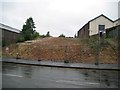
4
Former railway line at Kimpton Road
A railway bridge once crossed the road here. The line has been recently excavated in preparation for the creation of a guided busway.
Image: © Thomas Nugent
Taken: 18 Nov 2011
0.02 miles
5
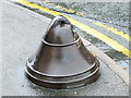
No nonsense bollard
Outside the corner door of The Windmill Inn Image, this bollard is presumably intended to keep traffic from cutting the corner on the pavement.
Image: © Thomas Nugent
Taken: 1 Oct 2007
0.02 miles
6
Kimpton Road
Looking up the hill from the Windmill public house. A railway bridge once crossed the road here. The line has been recently excavated in preparation for the creation of a guided busway.
Image: © Thomas Nugent
Taken: 18 Nov 2011
0.02 miles
7
Luton: Former Great Northern Railway Luton & Dunstable branch
This is the point at which the former Great Northern Railway's Luton & Dunstable branch crossed the former Gallows Road, now the A505 Kimpton Road. Having been opened around 1860 the line was finally closed to passenger traffic in 1965. Since this photograph was taken the old railway embankment has been demolished and a ramp built for the Luton Dunstable Busway's spur to Luton Airport. This is on the northern side of the road. The old railway bridge abutment on the southern side was still extant in 2011, and the route of the railway on the south side of the road does not appear to figure in current plans for the busway. See Image
The road is shown as Gallows Road on large scale Ordnance Survey mapping up to 1901, but by 1924 the mapping was showing that it had acquired its current moniker.
Image: © Nigel Cox
Taken: 26 Aug 2011
0.03 miles
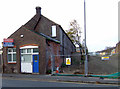
8
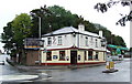
The Windmill Inn
At the corner of Windmill Road and Kimpton Road. The remains of a railway bridge which used to cross Kimpton Road can be seen to the left of the pub.
See the pub in its new colours here Image
Image: © Thomas Nugent
Taken: 1 Oct 2007
0.04 miles
9
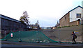
Former railway line at Kimpton Road
A railway bridge once crossed the road here. The line has been recently excavated in preparation for the creation of a guided busway.
Image: © Thomas Nugent
Taken: 18 Nov 2011
0.05 miles
10
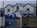
Factory on Kimpton Road
Part of the Hayward Tyler complex between the railway line and Windmill Road.
Image: © Thomas Nugent
Taken: 18 Nov 2011
0.05 miles