IMAGES TAKEN NEAR TO
Rothesay Road, LUTON, LU1 1RB
Introduction
This page details the photographs taken nearby to Rothesay Road, LU1 1RB by members of the Geograph project.
The Geograph project started in 2005 with the aim of publishing, organising and preserving representative images for every square kilometre of Great Britain, Ireland and the Isle of Man.

There are currently over 7.5m images from over14,400 individuals and you can help contribute to the project by visiting https://www.geograph.org.uk
Image Map
Images are licensed for reuse under creativecommons.org/licenses/by-sa/2.0
Notes
- Clicking on the map will re-center to the selected point.
- The higher the marker number, the further away the image location is from the centre of the postcode.
Image Listing (21 Images Found)
Images are licensed for reuse under creativecommons.org/licenses/by-sa/2.0
Image
Details
Distance
1
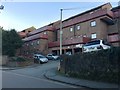
Lennon Court, Downs Road, Luton
Thanks to old maps it can be seen that these stepped blocks of flats with their heavy balconies were built on the site of 54 Napier Road and the side garden of No 1 Downs Road Image They first appear in part on an OS map of 1986.
Image: © Robin Stott
Taken: 24 Feb 2017
0.07 miles
2
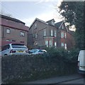
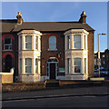
No 1 Downs Road, Luton
One of a handful of houses that first appear on an OS map of 1901. My estimate is that between 1949 and 1951 I attended a kindergarten here. It was called Cleveland School and was run by a Miss M E Greaves. Perhaps it was rather progressive because we made things of clay in a rear garden that may have been on two levels, stepping up towards Luton Cemetery, maps now tell me. There was a seemingly huge lawn to the east side, perhaps a former tennis court. We performed in plays on it in the summer to entertain the parents. One time I was the gardener who painted the white roses red in Alice in Wonderland while some diminutive curly-haired blonde stomped about shrieking "Off with his head!" That ground is now occupied by part of Lennon Court and its parking Image No 1 Downs Road appears to be flats. Thanks to staff at Luton Library who helped me track down the property in a 'Luton News' street directory of 1950.
Image: © Robin Stott
Taken: 24 Feb 2017
0.08 miles
3
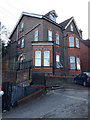
No 1 Downs Road, Luton
One of a handful of houses that first appear on an OS map of 1901. My estimate is that between 1949 and 1951 I attended a kindergarten here. It was called Cleveland School and was run by a Miss M E Greaves. Perhaps it was rather progressive because we made things of clay in a rear garden that may have been on two levels, stepping up towards Luton Cemetery, maps now tell me. There was a seemingly huge lawn to the east side, perhaps a former tennis court. We performed in plays on it in the summer to entertain the parents. One time I was the gardener who painted the white roses red in Alice in Wonderland while some diminutive curly-haired blonde stomped about shrieking "Off with his head!" That ground is now occupied by part of Lennon Court and its parking http://www.geograph.org.uk/photo/5293572 No 1 Downs Road appears to be flats. Thanks to staff at Luton Library who helped me track down the property in a 'Luton News' street directory of 1950.
Image: © Robin Stott
Taken: 24 Feb 2017
0.08 miles
4
No 1 Downs Road, Luton
One of a handful of houses that first appear on an OS map of 1901. My estimate is that between 1949 and 1951 I attended a kindergarten here. It was called Cleveland School and was run by a Miss M E Greaves. Perhaps it was rather progressive because we made things of clay in a rear garden that may have been on two levels, stepping up towards Luton Cemetery, maps now tell me. There was a seemingly huge lawn to the east side, perhaps a former tennis court. We performed in plays on it in the summer to entertain the parents. One time I was the gardener who painted the white roses red in Alice in Wonderland while some diminutive curly-haired blonde stomped about shrieking "Off with his head!" That ground is now occupied by part of Lennon Court and its parking hidden by the trees. No 1 Downs Road appears to be flats. Thanks to staff at Luton Library who helped me track down the property in a 'Luton News' street directory of 1950.
Image: © Robin Stott
Taken: 24 Feb 2017
0.08 miles
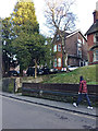
5
Samaritans, top of Cardiff Road, Luton
Decorative relief panels below windows are an eyecatching feature of older houses.
Image: © Robin Stott
Taken: 24 Feb 2017
0.11 miles
6
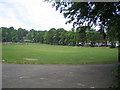
Luton: Brantwood Park
Luton's oldest public park viewed looking towards Brantwood Road and Ashburnham Road from Dallow Road.
Image: © Nigel Cox
Taken: 25 Jun 2006
0.14 miles
7

Luton from the air
Looking north just after take-off from the airport. The A505 passing round the town centre and the Midland Line railway can just be made out.
Image: © M J Richardson
Taken: 29 Jun 2015
0.14 miles
8
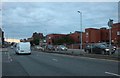
Stuart Street, Luton
The magistrates court is on the right
Image: © David Howard
Taken: 6 Sep 2020
0.18 miles
9

Date stone, Luton Delivery Office
Plaques of this kind are often to be found on public service buildings designed by architects in the Office of Works, and its successors, the Ministry of Works, and the Ministry of Public Building and Works.
Image: © Jim Osley
Taken: 21 Mar 2015
0.18 miles
10
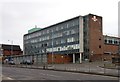
Royal Mail Delivery Office
Built 1957 to the designs of Ministry of Works architect Thomas Winterburn. Greatly influenced by the prevailing modernist architecture of the day (inspired by the work of Swiss architect Le Corbusier).
Image: © Jim Osley
Taken: 21 Mar 2015
0.18 miles