IMAGES TAKEN NEAR TO
LS9 8JR
Introduction
This page details the photographs taken nearby to LS9 8JR by members of the Geograph project.
The Geograph project started in 2005 with the aim of publishing, organising and preserving representative images for every square kilometre of Great Britain, Ireland and the Isle of Man.

There are currently over 7.5m images from over14,400 individuals and you can help contribute to the project by visiting https://www.geograph.org.uk
Image Map
Images are licensed for reuse under creativecommons.org/licenses/by-sa/2.0
Notes
- Clicking on the map will re-center to the selected point.
- The higher the marker number, the further away the image location is from the centre of the postcode.
Image Listing (230 Images Found)
Images are licensed for reuse under creativecommons.org/licenses/by-sa/2.0
Image
Details
Distance
1
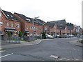
Houses on Cross Catherine Street, Leeds
Fairly recent housing. The road has a residents only parking restriction.
Image: © Stephen Craven
Taken: 12 Feb 2016
0.01 miles
2
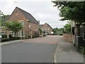
Dolphin Court - Cross Catherine Street
Image: © Betty Longbottom
Taken: 29 May 2013
0.03 miles
3
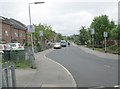
Cross Catherine Street - viewed from Wesley Place
Image: © Betty Longbottom
Taken: 29 May 2013
0.03 miles
4
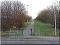
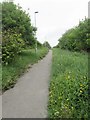
Blocked footpath, Leeds
See Image and Image showing this path in 2013 still open through to Upper Accommodation Road. By 2016 it had been blocked by a security fence. It was probably not a public right of way.
Image: © Stephen Craven
Taken: 12 Feb 2016
0.03 miles
6
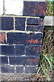
Benchmark on Wesley Place railway bridge
Ordnance Survey cut mark benchmark described on the Bench Mark Database at http://www.bench-marks.org.uk/bm50595
Image: © Roger Templeman
Taken: 6 Aug 2013
0.04 miles
7
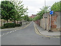
East Field Street - Cross Catherine Street
Image: © Betty Longbottom
Taken: 29 May 2013
0.05 miles
8
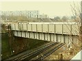
Bridge over the railway, Wesley Place, Leeds
See Image for a view along the bridge at road level. The bridge is shown on old maps but this steel bridge looks like a post-war replacement of an earlier structure. The original was probably a brick arch like the one a short distance to the east Image
Image: © Stephen Craven
Taken: 12 Feb 2016
0.05 miles
9
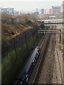
Richmond Hill railway cutting east of Leeds
The railway runs in a deep cutting, lined with brick retaining walls, for about 900 metres through Richmond Hill. Behind the photographer it actually runs in a tunnel for a short distance. It must have been a close call whether to build a tunnel for the whole length of the cutting. This view is looking west from upper Accommodation Road bridge Image
The train in the picture is being held at a signal on the slow line, presumably waiting for a faster service to overtake it.
Image: © Stephen Craven
Taken: 12 Feb 2016
0.05 miles
10
Dolphin Street - Cross Catherine Street
Image: © Betty Longbottom
Taken: 29 May 2013
0.06 miles