IMAGES TAKEN NEAR TO
Ladywood Mead, LEEDS, LS8 2LZ
Introduction
This page details the photographs taken nearby to Ladywood Mead, LS8 2LZ by members of the Geograph project.
The Geograph project started in 2005 with the aim of publishing, organising and preserving representative images for every square kilometre of Great Britain, Ireland and the Isle of Man.

There are currently over 7.5m images from over14,400 individuals and you can help contribute to the project by visiting https://www.geograph.org.uk
Image Map (Loading...)


Getting Data...Please wait
Leaflet Map data © OpenStreetMap
Images are licensed for reuse under creativecommons.org/licenses/by-sa/2.0
Notes
- Clicking on the map will re-center to the selected point.
- The higher the marker number, the further away the image location is from the centre of the postcode.
Image Listing (105 Images Found)
Images are licensed for reuse under creativecommons.org/licenses/by-sa/2.0
Image
Details
Distance
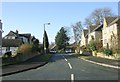

4

Asket Hill, looking down towards Wetherby Road
Asket Hill is an ancient route but the road now mainly serves a housing estate occupying the former grounds of Asket Hall.
Image: © Stephen Craven
Taken: 7 Jul 2018
0.07 miles
5
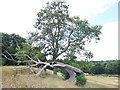
Live and dead trees at the top of Asket Hill
This northern slope of the hill is a public open space. One of the trees looks as if it might have bee the victim of a lightning strike.
Image: © Stephen Craven
Taken: 7 Jul 2018
0.07 miles
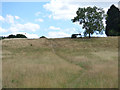
6
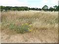
Tall grass at the top of Asket Hill
This northern slope of the hill is a public open space. It appears to be left unmown for the grasses and meadow flowers to grow to seed.
Image: © Stephen Craven
Taken: 7 Jul 2018
0.07 miles
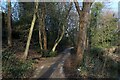
7
Path up Asket Hill
This northern slope of the hill is a public open space. Compare Image for a winter view.
Image: © Stephen Craven
Taken: 7 Jul 2018
0.07 miles
8
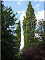
Poplars alongside the Wykebeck Way
There are about a dozen of these tall trees in two tight clumps.
Image: © Stephen Craven
Taken: 7 Jul 2018
0.09 miles
9
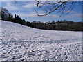
Lupton's Field, Asket Hill
A 'local green space' with an ideal slope for sledging. Only a couple out at this time - there were more later in the day.
Image: © E Gammie
Taken: 7 Feb 2009
0.09 miles
10
Wykebeck Woods
As the name suggests - woods beside Wyke Beck. The path is part of a green corridor that runs southwards from Roundhay Park to Rothwell, via Temple Newsam.
Image: © Chris Heaton
Taken: 23 Feb 2022
0.10 miles